Högsjö
(c) Bengt A Lundberg / Riksantikvarieämbetet, CC BY 2.5 | |
| Państwo | |
|---|---|
| Region | |
| Gmina | |
| Powierzchnia | 0,98[1] km² |
| Populacja (2018) • liczba ludności • gęstość | |
| Nr kierunkowy | (+46) 151 |
| Kod pocztowy | 640 10 |
| Portal | |
Högsjö – miejscowość (tätort) w Szwecji, w regionie administracyjnym (län) Södermanland (gmina Vingåker).
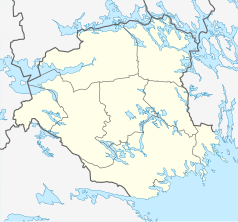
Miejscowość położona jest w zachodniej części prowincji historycznej (landskap) Södermanland pomiędzy jeziorami Ölångssjön (Ölången) i Högsjön lezącymi w systemie rzeki Nyköpingsån, ok. 10 km na zachód od Vingåker.
Högsjö rozwinęło się jako osada przemysłowa. Energię wodną w tej okolicy wykorzystywano od XVI w., zajmując się m.in. obróbką żelaza. W XIX w. w Högsjö zostały założone zakłady tekstylne (Högsjö bruk)[2].
W 2010 r. Högsjö liczyło 713 mieszkańców[3].
Przypisy
- ↑ a b c Statistiska tätorter 2018; befolkning, landareal, befolkningstäthet. Statistikmyndigheten SCB, 2020-03-20. [dostęp 2020-09-08]. [zarchiwizowane z tego adresu (2020-03-24)]. (szw.).
- ↑ Vingåkers kommun: Högsjö. [dostęp 2014-12-08]. [zarchiwizowane z tego adresu (2014-12-14)]. (szw.).
- ↑ Statistiska centralbyrån: Befolkning och arealer. [dostęp 2014-12-08]. (szw.).
Media użyte na tej stronie
(c) Bengt A Lundberg / Riksantikvarieämbetet, CC BY 2.5
Felaktigheter kan även anmälas till denna sida.
Motiv: Västra Vingåker, Högsjö Gårds kapell
(c) Lokal_Profil, CC BY-SA 2.5
This coat of arms was drawn based on its blazon which – being a written description – is free from copyright. Any illustration conforming with the blazon of the arms is considered to be heraldically correct. Thus several different artistic interpretations of the same coat of arms can exist. The design officially used by the armiger is likely protected by copyright, in which case it cannot be used here.
Individual representations of a coat of arms, drawn from a blazon, may have a copyright belonging to the artist, but are not necessarily derivative works.
Autor: Erik Frohne, Licencja: CC BY 3.0
Location map of Södermanland county in Sweden
Equirectangular projection, N/S stretching 195 %. Geographic limits of the map:
- N: 59.60° N
- S: 58.50° N
- W: 15.50° E
- E: 17.80° E


