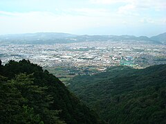
Hadano
| |||||||
 Panorama miasta | |||||||
| |||||||
| Państwo | |||||||
|---|---|---|---|---|---|---|---|
| Prefektura | Kanagawa | ||||||
| Wyspa | Honsiu | ||||||
| Region | Kantō | ||||||
| Burmistrz | Yoshiyuki Furuya (od 31.01.2006) | ||||||
| Powierzchnia | 103,76 km² | ||||||
| Populacja (2015.10.01) • liczba ludności • gęstość | 167 378 1613 os./km² | ||||||
| Kod pocztowy | 257-8501 | ||||||
| Symbole japońskie | |||||||
| Drzewo | Kamelia mała, magnolia japońska | ||||||
| Kwiat | Goździk, hortensja ogrodowa | ||||||
| Ptak | Wierzbownik japoński | ||||||
| Strona internetowa | |||||||
| Portal | |||||||
Hadano (jap. 秦野市 Hadano-shi) – miasto w Japonii, w prefekturze Kanagawa, w środkowej części wyspy Honsiu.
Położenie
Miasto leży w centrum prefektury Kanagawa. Graniczy z:
Historia
1 kwietnia 1889 roku, po restauracji Meiji, w wyniku połączenia siedmiu miejscowości z powiatu Ōsumi powstało miasteczko Hadano (chō). 1 kwietnia 1896 roku miejscowość stała się częścią powiatu Naka. Hadano otrzymało prawa miejskie 1 stycznia 1955 roku[1][2].
Populacja
Zmiany w populacji Hadano w latach 1970–2015:
| Rok | Populacja |
|---|---|
| 1970 | 75 226 |
| 1975 | 103 663 |
| 1980 | 123 133 |
| 1985 | 141 803 |
| 1990 | 155 620 |
| 1995 | 164 722 |
| 2000 | 168 142 |
| 2005 | 168 317 |
| 2010 | 170 145 |
| 2015 | 167 378 |
Urodzeni w Hadano
- Rinko Kikuchi – japońska aktorka
Miasta partnerskie
Przypisy
- ↑ 第2章 秦野市の概要 (jap.). city.hadano.kanagawa.jp. [dostęp 2017-12-23].
- ↑ 履歴情報 神奈川県 (jap.). uub.jp. [dostęp 2021-01-13].
Linki zewnętrzne
- Oficjalna strona miasta (jap.)
Media użyte na tej stronie
Autor: Maximilian Dörrbecker (Chumwa), Licencja: CC BY-SA 3.0
Location map of Japan
Equirectangular projection.
Geographic limits to locate objects in the main map with the main islands:
- N: 45°51'37" N (45.86°N)
- S: 30°01'13" N (30.02°N)
- W: 128°14'24" E (128.24°E)
- E: 149°16'13" E (149.27°E)
Geographic limits to locate objects in the side map with the Ryukyu Islands:
- N: 39°32'25" N (39.54°N)
- S: 23°42'36" N (23.71°N)
- W: 110°25'49" E (110.43°E)
- E: 131°26'25" E (131.44°E)
The flag of Navassa Island is simply the United States flag. It does not have a "local" flag or "unofficial" flag; it is an uninhabited island. The version with a profile view was based on Flags of the World and as a fictional design has no status warranting a place on any Wiki. It was made up by a random person with no connection to the island, it has never flown on the island, and it has never received any sort of recognition or validation by any authority. The person quoted on that page has no authority to bestow a flag, "unofficial" or otherwise, on the island.
Autor: Created by LERK, Licencja: Copyrighted free use
The shadow picture of Kanagawa Prefecture, Japan
Flag of Hadano, Kanagawa
Autor: ja: 利用者:Lincun, Licencja: CC BY-SA 3.0
Map of Kanagawa Prefecture, Japan.
Flag of Kanagawa Prefecture.
Emblem of Hadano, Kanagawa


