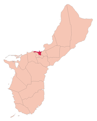
Hagåtña
 | |
| Państwo | |
|---|---|
| Terytorium nieinkorporowane | |
| Zarządzający | John A. Cruz↗ |
| Powierzchnia | 2,6 km² |
| Populacja (2010) • liczba ludności |
|
| Kod pocztowy | 96910 |
| Strona internetowa | |
| Portal | |

Hagåtña (do 1998: Agaña, Agana) – stolica i jeden z okręgów administracyjnych Guamu (związkowego terytorium USA). Okręg ma powierzchnię 3 km²[1], a zamieszkany jest przez 1051 osób (dane spisowe z 2010)[2].
Znajduje się tu siedziba gubernatora, parlament i ministerstwa oraz uniwersytet i siedziba Mikronezyjskiej Rady Turystyki.
Położenie
Hagåtña jest położona w środkowej części zachodniego wybrzeża wyspy przy ujściu rzeki Agania.
Historia
W 1940 roku liczyło około 10 tysięcy mieszkańców. Podczas II wojny światowej całkowicie zniszczone. Odbudowa była utrudniona przez skomplikowaną sytuację prawną wielu gruntów. Od czasu II wojny światowej liczba ludności nieprzerwanie, chociaż powoli, wzrasta.
Współpraca
Przypisy
- ↑ Municipalities of Guam. Administrative Divisions of Countries („Statoids”). [dostęp 2014-04-09].
- ↑ Guam Statistical Yearbook 2010. Bureau of Statistics and Plans, Government of Guam. [dostęp 2014-04-09].
Bibliografia
- Encyklopedia Audiowizualna Britannica – Geografia I, Rafał Jasiulewicz (red.), Leszek Baraniecki, Poznań: Wydawnictwo Kurpisz, 2006, ISBN 83-60563-07-1, ISBN 978-83-60563-07-6, ISBN 83-60563-04-7, ISBN 978-83-60563-04-5, ISBN 1-59339-330-X, ISBN 978-1-59339-330-4, OCLC 838992809.
Linki zewnętrzne
- O stolicy na stronie rządu Guam. ns.gov.gu. [zarchiwizowane z tego adresu (2005-08-28)].
Media użyte na tej stronie
The flag of Navassa Island is simply the United States flag. It does not have a "local" flag or "unofficial" flag; it is an uninhabited island. The version with a profile view was based on Flags of the World and as a fictional design has no status warranting a place on any Wiki. It was made up by a random person with no connection to the island, it has never flown on the island, and it has never received any sort of recognition or validation by any authority. The person quoted on that page has no authority to bestow a flag, "unofficial" or otherwise, on the island.
Autor: Alexrk2, Licencja: CC BY-SA 3.0
Ta mapa została stworzona za pomocą GeoTools.
Autor: Uwe Dedering, Licencja: CC BY-SA 3.0
Location map of Oceania.
- Projection: Lambert azimuthal equal-area projection.
- Area of interest:
- N: 35.0° N
- S: -55.0° N
- W: 110.0° E
- E: 230.0° E (This is -130° E)
- Projection center:
- NS: -10.0° N
- WE: 170.0° E
- GMT projection: -JA170/-5/20c
- GMT region: -R79.58168799459713/-44.42200097096855/-120.83787447194456/33.90289238708686r
- GMT region for grdcut: -R80.0/-63.0/260.0/39.0r
- Made with Natural Earth. Free vector and raster map data @ naturalearthdata.com.
Autor: Aotearoa, Licencja: CC-BY-SA-3.0
Okręg administracyjny Hagåtña na mapie wyspy Guam.
Pre-War Hagåtña!
The flag of Guam, courtesy an e-mail from the author of xrmap. Modifications by Denelson83.
Autor: Hajime NAKANO from Tokyo, Japan, Licencja: CC BY 2.0
Hagatna, Guam as seen from Fort Apugan


