Hainault (stacja metra)
(c) Sunil060902, CC-BY-SA-3.0 Budynek stacji Hainault, 2007 | |
| Państwo | |
|---|---|
| Miejscowość | Londyn |
| Dzielnica | Hainault |
| Data otwarcia | 1948 |
| Liczba peronów | 3 |
| Central Line | |
| Poprzednia stacja | Fairlop |
| Następna stacja | Grange Hill |
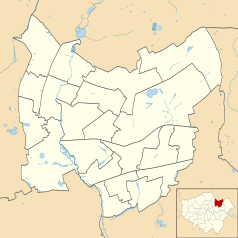
Położenie na mapie gminy Redbridge Contains Ordnance Survey data © Crown copyright and database right, CC BY-SA 3.0 | |
Położenie na mapie Wielkiej Brytanii (c) Karte: NordNordWest, Lizenz: Creative Commons by-sa-3.0 de | |
Położenie na mapie Wielkiego Londynu Contains Ordnance Survey data © Crown copyright and database right, CC BY-SA 3.0 | |
| Portal | |
Hainault – stacja londyńskiego metra położona w północno-wschodniej części miasta, na trasie Central Line pomiędzy stacjami Fairlop a Grange Hill. Znajduje się w dzielnicy Hainault w gminie London Borough of Redbridge, w czwartej strefie biletowej[1].
Historia
Stacja została otwarta 1 maja 1903 roku jako część Great Eastern Railway i została zaprojektowana celem stymulacji wzrostu rejonów podmiejskich, jednak w 1908 roku została zamknięta ze względu na niewielką liczbę pasażerów. Jej ponowne otwarcie nastąpiło 2 marca 1930 roku. W międzyczasie Great Eastern Railway połączyły się z innymi przedsiębiorstwami kolejowymi tworząc London & North Eastern Railway. W wyniku "New Works Programme" w latach 1935-1904, stacja została włączona w sieć Central Line, jednak prace nad jej przebudową zostały wstrzymane z powodu wybuchu II wojny światowej. Działalność stacji ostatecznie została wznowiona w 1946 roku[2].
W 1947 roku ostatecznie zawieszono przewozy pociągami parowymi z Hainault, w ich miejsce 31 maja 1948 roku pojawiły się elektryczne pociągi metra Central Line[2].
Połączenia
Stacja obsługiwana jest przez autobusy linii 150, 247 i N8.
Galeria
Przypisy
- ↑ Tube stations - Fairlop (ang.). Transport For London. [dostęp 2012-01-10].
- ↑ a b Central line facts (ang.). Transport For London. [dostęp 2012-01-10].
Media użyte na tej stronie
(c) Karte: NordNordWest, Lizenz: Creative Commons by-sa-3.0 de
Location map of the United Kingdom
Contains Ordnance Survey data © Crown copyright and database right, CC BY-SA 3.0
Map of Greater London, UK with the following information shown:
- Administrative borders
- Coastline, lakes and rivers
- Roads and railways
- Urban areas
The data includes both primary routes and railway lines.
Equirectangular map projection on WGS 84 datum, with N/S stretched 160%
Geographic limits:
- West: 0.57W
- East: 0.37E
- North: 51.72N
- South: 51.25N
Contains Ordnance Survey data © Crown copyright and database right, CC BY-SA 3.0
Blank map of the London Borough of Redbridge, showing electoral wards.
Equirectangular map projection on WGS 84 datum, with N/S stretched 160%
Geographic limits:
- West: 0
- East: 0.16E
- North: 51.635N
- South: 51.535N
Autor: Sunil060902, Licencja: CC BY-SA 3.0
Hainault tube station platform roundel
Autor: Sunil060902, Licencja: CC BY-SA 3.0
Hainault tube station platform 2 looking north, normally used by Woodford trains proceeding via Grange Hill, after a pause of a few minutes. These trains run every 20 minutes. Terminating trains also use this platform as well as platform 1 on the far right and platform 3 on the far left. Due to rebuilding in the 1940s, platform 1 is the only remaining part of the station dating from Great Eastern days. Lift installation works are in progress at the northern ends of platform 1 and 2/3. Date of photo April 2009.
(c) Sunil060902, CC-BY-SA-3.0
Hainault tube station building, on New North Road. Refurbishment work in progress on the other side of the railway bridge. Sunil060902, 11th November 2007.


