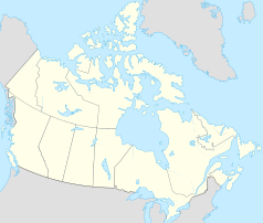
Haldimand County
| ||||
 | ||||
| Państwo | ||||
|---|---|---|---|---|
| Prowincja | ||||
| Prawa miejskie | 2001 | |||
| Powierzchnia | 1250,45 km² | |||
| Populacja (2021) • liczba ludności • gęstość |
| |||
| Strona internetowa | ||||
| Portal | ||||
Haldimand County – miasto (town) w kanadyjskiej prowincji Ontario, podjednostka podziału statystycznego (jako city; census subdivision)[1]. Według spisu powszechnego z 2021 obszar miasta to: 1250,45 km², a zamieszkiwało wówczas ten obszar 49 216 osób (gęstość zaludnienia 39,4 os./km²)[2].
Miejscowość powstała w wyniku połączenia w 2001 miast Dunville i Haldimand oraz fragmentów Nanticoke w organizm typu single-tier municipality w następstwie rozwiązania regional municipality Haldimand-Norfolk[3].
Przypisy
- ↑ Haldimand County, Natural Resources Canada / Ressources naturelles Canada – nrcan.gc.ca [dostęp 2022-03-25]; Haldimand County, City (CY) [Census subdivision], Ontario – Census Profile, 2021 Census, Statistics Canada / Statistique Canada – statcan.gc.ca [dostęp 2022-03-05].
- ↑ Haldimand County, City (CY) [Census subdivision], Ontario – Census Profile, 2021 Census, Statistics Canada / Statistique Canada – statcan.gc.ca [dostęp 2022-03-05].
- ↑ Hugh J. Gayler, John N. Jack, Haldimand County, The Canadian Encyclopedia – thecanadianencyclopedia.ca [dostęp 2022-03-05].
Media użyte na tej stronie
Autor: Yug, Licencja: CC-BY-SA-3.0
cropped version of Carte administrative du Canada.svg for map location.
Flag of Ontario.
Autor: NordNordWest, Licencja: CC BY-SA 3.0
Location map of Ontario, Canada
Autor: Michael McGregor, Licencja: CC BY 2.5
A view of the Argyle St. bridge over the Grand River in Caledonia Ontario.


