Hampstead
| ||||
| ||||
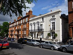
(c) Christine Matthews, CC BY-SA 2.0 Downshire Hill | ||||
| Państwo | ||||
| Kraj | ||||
| Region | Wielki Londyn | |||
| Miasto | Londyn | |||
| Gmina | Camden | |||
Położenie na mapie Wielkiego Londynu Contains Ordnance Survey data © Crown copyright and database right, CC BY-SA 3.0 | ||||
| 51°33′15″N 0°10′28″W/51,554100 -0,174400 | ||||
| Portal | ||||
Hampstead – dzielnica w północnym Londynie, wchodzi w skład London Borough of Camden i położona jest ok. 6,5 km na północny zachód od Charing Cross. W dzielnicy Hampstead znajduje się rozległy teren parkowy Hampstead Heath. Jest to luksusowa dzielnica, w której swoje posiadłości ma wielu brytyjskich, a także światowej sławy dygnitarzy.
W tej dzielnicy mieszkał m.in. Zygmunt Freud. Dziś znajduje się w niej jego muzeum.
Ciekawe miejsca:
Linki zewnętrzne
Media użyte na tej stronie
Contains Ordnance Survey data © Crown copyright and database right, CC BY-SA 3.0
Map of Greater London, UK with the following information shown:
- Administrative borders
- Coastline, lakes and rivers
- Roads and railways
- Urban areas
The data includes both primary routes and railway lines.
Equirectangular map projection on WGS 84 datum, with N/S stretched 160%
Geographic limits:
- West: 0.57W
- East: 0.37E
- North: 51.72N
- South: 51.25N
Flag of England. Saint George's cross (a red cross on a white background), used as the Flag of England, the Italian city of Genoa and various other places.
(c) Christine Matthews, CC BY-SA 2.0
Downshire Hill, Hampstead, London NW3, near to Hampstead, Camden, Great Britain. Houses in Downshire Hill near Rosslyn Hill.
Autor: NordNordWest, Licencja: CC BY-SA 3.0
Location map of the United Kingdom


