Handa
| |||||||
 | |||||||
| Państwo | |||||||
|---|---|---|---|---|---|---|---|
| Prefektura | |||||||
| Wyspa | |||||||
| Region | |||||||
| Burmistrz | Sumio Sakakibara (od 24.06.2009) | ||||||
| Powierzchnia | 47,42 km² | ||||||
| Populacja (2015.10.01) • liczba ludności • gęstość |
| ||||||
| Nr kierunkowy | (+81) 569 | ||||||
| Kod pocztowy | 475-8666 | ||||||
| Symbole japońskie | |||||||
| Drzewo | |||||||
| Kwiat | Różanecznik indyjski | ||||||
| Strona internetowa | |||||||
| Portal | |||||||
Handa (jap. 半田市 Handa-shi) – miasto w Japonii, w prefekturze Aichi, w środkowej części wyspy Honsiu, na południowy wschód od Nagoi u nasady półwyspu Chita.
1 października 1889 roku wioska Handa zdobyła status miasteczka. 1 października 1937 roku Handa połączyło się z miasteczkami Kamezaki i Narawa (z powiatu Chita) zdobywając status miasta[1].
Gospodarka
W mieście rozwinął się przemysł spożywczy, odzieżowy oraz maszynowy[2].
Uczelnie
- Nihon Fukushi University – kampus Handa
Populacja
Zmiany w populacji Handy w latach 1970–2015:
| Rok | Populacja |
|---|---|
| 1970 | 80 663 |
| 1975 | 85 824 |
| 1980 | 89 328 |
| 1985 | 92 883 |
| 1990 | 99 550 |
| 1995 | 106 452 |
| 2000 | 110 837 |
| 2005 | 115 845 |
| 2010 | 118 829 |
| 2015 | 116 936 |
Miasta partnerskie
 Japonia: Nanto (od 28.04.1997)
 Stany Zjednoczone: Midland (od 05.06.1981)[3]
 Australia: Port Macquarie (od 14.04.1990)[3]
 Chiny: Xuzhou (od 27.05.1993)[3]
Przypisy
- ↑ 履歴情報 神奈川県 (jap.). uub.jp. [dostęp 2021-03-04].
- ↑ Handa, [w:] Encyklopedia PWN [online] [dostęp 2021-07-07].
- ↑ a b c Handa (ang.). japanese-cities.com. [dostęp 2017-08-02]. [zarchiwizowane z tego adresu (2017-08-02)].
Linki zewnętrzne
- Oficjalna strona miasta (jap.)
Media użyte na tej stronie
Autor: Maximilian Dörrbecker (Chumwa), Licencja: CC BY-SA 3.0
Location map of Japan
Equirectangular projection.
Geographic limits to locate objects in the main map with the main islands:
- N: 45°51'37" N (45.86°N)
- S: 30°01'13" N (30.02°N)
- W: 128°14'24" E (128.24°E)
- E: 149°16'13" E (149.27°E)
Geographic limits to locate objects in the side map with the Ryukyu Islands:
- N: 39°32'25" N (39.54°N)
- S: 23°42'36" N (23.71°N)
- W: 110°25'49" E (110.43°E)
- E: 131°26'25" E (131.44°E)
The flag of Navassa Island is simply the United States flag. It does not have a "local" flag or "unofficial" flag; it is an uninhabited island. The version with a profile view was based on Flags of the World and as a fictional design has no status warranting a place on any Wiki. It was made up by a random person with no connection to the island, it has never flown on the island, and it has never received any sort of recognition or validation by any authority. The person quoted on that page has no authority to bestow a flag, "unofficial" or otherwise, on the island.
Autor: Tawashi2006, Licencja: CC-BY-SA-3.0
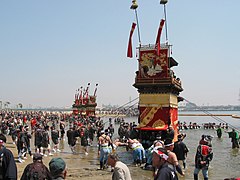
Kamezaki Shiohi Matsuri on the beach.
The Kaō-Guruma float of Nishi-Gumi
Autor: Created by LERK, Licencja: Copyrighted free use
The shadow picture of Aichi Prefecture, Japan
Flag of Handa, Aichi
Autor: Lincun, Licencja: CC BY-SA 3.0
Map of Aichi Prefecture, Japan.


