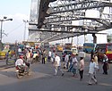
Howrah
| ||
 | ||
| Państwo | ||
| Stan | Bengal Zachodni | |
| Dystrykt | Howrah | |
| Burmistrz | Mamta Jaiswal | |
| Powierzchnia | 51,74 km² | |
| Wysokość | 12 m n.p.m. | |
| Populacja (2001) • liczba ludności • gęstość | 1 007 532 19496 os./km² | |
| Nr kierunkowy | +91 33 | |
| Kod pocztowy | 711101 | |
| Tablice rejestracyjne | WB-11 | |
Położenie na mapie Bengalu Zachodniego (c) Karte: NordNordWest, Lizenz: Creative Commons by-sa-3.0 de | ||
Położenie na mapie Indii | ||
| Strona internetowa | ||

Howrah (beng. হাওড়া, dewanagari हावरा) – miasto w Indiach, w zespole miejskim Kalkuty, nad rzeką Hugli.
Miasto jest dużym ośrodkiem przemysłu jutowego i bawełnianego. Posiada port morski ze stocznią, hutę aluminium, mieści się tam również najstarszy w Indiach ogród botaniczny, Acharya Jagadish Chandra Bose Indian Botanic Garden. Liczba ludności w 2003 roku wynosiła ok. 1 mln.
Media użyte na tej stronie
(c) Uwe Dedering z niemieckiej Wikipedii, CC BY-SA 3.0
Location map of India.
Equirectangular projection. Strechted by 106.0%. Geographic limits of the map:
- N: 37.5° N
- S: 5.0° N
- W: 67.0° E
- E: 99.0° E
The Flag of India. The colours are saffron, white and green. The navy blue wheel in the center of the flag has a diameter approximately the width of the white band and is called Ashoka's Dharma Chakra, with 24 spokes (after Ashoka, the Great). Each spoke depicts one hour of the day, portraying the prevalence of righteousness all 24 hours of it.
Autor: Ramakrishna Mission, Belur Math, Licencja: CC BY-SA 3.0
Photo of the Belur Math
(c) Karte: NordNordWest, Lizenz: Creative Commons by-sa-3.0 de
Location map of West Bengal, India
Autor: Myself, Licencja: CC-BY-SA-3.0
The approach to Howrah bridge from Howrah side


