Hariana
| stan | |
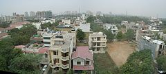
 Dzielnica mieszkalna w Gurgaon | |
| Państwo | |
|---|---|
| Siedziba | Czandigarh |
| Kod ISO 3166-2 | IN-HR |
| Gubernator | A.R. Kidwai |
| Powierzchnia | 44 212 km² |
| Populacja (2011) • liczba ludności | 25 353 081[1] |
| • gęstość | 573,4 os./km² |
| Języki urzędowe | hindi |
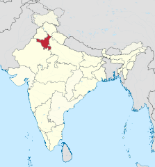
Położenie na mapie Indii | |
| Strona internetowa | |
Hariana (również pisana jako Harijana, hindi हरियाणा, trb.: Harijana, trl.: Hariyāṇā; ang. Haryana) – stan w północnych Indiach. Sąsiaduje ze stanami: Pendżab na północnym zachodzie, Himachal Pradesh na północy i Radżastanem na południowym zachodzie. Rzeka Jamuna stanowi wschodnią granicę ze stanami Uttarakhand i Uttar Pradesh.
W 2011 pod względem liczby ludności był to 17. największy stan Indii; w 2001 zajmował 16. miejsce[1]. Przez terytorium stanu przepływają rzeki: Ghaggar, Markanda, Tangri i Sahib.
Podział administracyjny
Stan Hariana dzieli się na następujące okręgi:
|
|
Przypisy
- ↑ a b 3. Size, Growth Rate and Distribution of Population, [w:] 2011 Census of India, Office of the Registrar General & Census Commissioner, India [dostęp 2019-08-02] [zarchiwizowane z adresu 2019-05-31].
Media użyte na tej stronie
The Flag of India. The colours are saffron, white and green. The navy blue wheel in the center of the flag has a diameter approximately the width of the white band and is called Ashoka's Dharma Chakra, with 24 spokes (after Ashoka, the Great). Each spoke depicts one hour of the day, portraying the prevalence of righteousness all 24 hours of it.
Autor: TUBS
Location of state XY (see filename) in India
Autor: Patrice78500, Licencja: CC BY-SA 3.0
Vue de quartier résidentiel à Gurgaon


