Harlem (Nowy Jork)
| Dzielnica Nowego Jorku | |
.jpg) Apollo Theater przy 125th Street w Harlemie (2006) | |
| Dewiza: Making It! | |
| Państwo | |
|---|---|
| Stan | |
| Miasto | |
| Dzielnica | Manhattan |
| Data założenia | 1658 |
| Powierzchnia | 10,03 km² |
| Populacja (2000[1][2][3]) • liczba ludności |
|
| • gęstość | 33,000 os./km² |
| Kod pocztowy | 10026, 10027, 10029, 10030, 10031, 10035, 10037, 10039 |
Plan Harlem | |
Położenie na mapie Nowego Jorku  | |
Położenie na mapie Stanów Zjednoczonych  | |
Położenie na mapie stanu Nowy Jork  (c) NordNordWest, CC BY 3.0 | |
| Portal | |
Harlem – dzielnica (neighborhood) Nowego Jorku, zajmuje większość północnej części okręgu (ang. borough) Manhattan. Jej populacja w większości składa się z Afroamerykanów.
Historia
W 1658 r. została tu założona przez Holendrów wioska Nieuw Haarlem. Nazwa pochodzi od miasta Haarlem w Holandii.
Od około 1900 r. dzielnica rozwijała się jako centrum populacji afroamerykańskiej. W latach dwudziestych stała się ośrodkiem twórczości literackiej i ruchu intelektualnego, zwanego renesansem Harlemu.
Pod koniec II wojny światowej warunki mieszkaniowe w dzielnicy pogorszyły się. Dziś duże obszary dzielnicy zajmują zarówno slumsy, jak i nowoczesne biura. Tu mieści się najsłynniejsze boisko do streetballa – Rucker Park. Znajduje się tam sklep odzieżowy Harlem, który słynie ze sprzedaży odzieży luźnej.
Z Harlemu pochodzą m.in. Cam’ron, Big L, Moby, Immortal Technique, ASAP Rocky czy Azealia Banks.
Podział administracyjny
- Harlem Zachodni
- Harlem Centralny
- Harlem Wschodni – zwany Hiszpańskim lub El Barrio
Zabytki i ciekawe miejsca[4]
- Abyssinian Baptist Church – najbardziej znany na Harlemie zabytek, kościół abisyński
- El Museo del Barrio – muzeum poświęcone sztuce i kulturze karaibskiej
- Graham Court – zabytkowe apartamenty
- La Marqueta – obecnie zamknięty, historyczny podziemny targ przy stacji kolejowej
- Morningside Park – największy na terenie Harlemu park
- Museum of the City of New York – muzeum historii miasta Nowego Jorku
- Rucker Park
Galeria zdjęć

Jedna z ulic na Harlemie

Budynek mieszkalny tzw. rowhouse stojący się przy ulicy 135th Street, wzniesiony został dla afroamerykańskiej ludności w latach trzydziestych
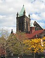
Kościół episkopalny pod wezwaniem świętego Marcina u zbiegu alei Lenox Avenue i ulicy 122nd Street

Gmach Hotelu Theresa na narożniku Adam Clayton Powell Jr. Boulevard i ulicy 125th Street
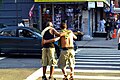
Scena przy ulicy na Harlemie

Rzeka Harlem przepływająca przez Harlem (po lewej stronie) i Bronx (po prawej stronie)

Scena z zamieszek na Harlemie w roku 1964

Przypisy
- ↑ https://web.archive.org/web/20140825143942/http://www.nyc.gov/html/dcp/pdf/lucds/mn10profile.pdf.
- ↑ https://web.archive.org/web/20130928060108/http://www.nyc.gov/html/dcp/pdf/lucds/mn9profile.pdf.
- ↑ https://web.archive.org/web/20130928060104/http://www.nyc.gov/html/dcp/pdf/lucds/mn11profile.pdf.
- ↑ Landmarks – Harlem, Gospe, Jazz and New York Tours. harlemspirituals.com. [zarchiwizowane z tego adresu (2010-10-31)]..
|

Media użyte na tej stronie
Autor: Alexrk2, Licencja: CC BY 3.0
Ta mapa została stworzona za pomocą GeoTools.
Autor: Uwe Dedering, Licencja: CC BY-SA 3.0
Location map of the USA (without Hawaii and Alaska).
EquiDistantConicProjection:
Central parallel:
* N: 37.0° N
Central meridian:
* E: 96.0° W
Standard parallels:
* 1: 32.0° N
* 2: 42.0° N
Made with Natural Earth. Free vector and raster map data @ naturalearthdata.com.
Formulas for x and y:
x = 50.0 + 124.03149777329222 * ((1.9694462586094064-({{{2}}}* pi / 180))
      * sin(0.6010514667026994 * ({{{3}}} + 96) * pi / 180))
y = 50.0 + 1.6155950752393982 * 124.03149777329222 * 0.02613325650382181
      - 1.6155950752393982  * 124.03149777329222 *
     (1.3236744353715044  - (1.9694462586094064-({{{2}}}* pi / 180))
      * cos(0.6010514667026994 * ({{{3}}} + 96) * pi / 180))
(c) NordNordWest, CC BY 3.0
Location map of the State of New York, USA

The flag of Navassa Island is simply the United States flag. It does not have a "local" flag or "unofficial" flag; it is an uninhabited island. The version with a profile view was based on Flags of the World and as a fictional design has no status warranting a place on any Wiki. It was made up by a random person with no connection to the island, it has never flown on the island, and it has never received any sort of recognition or validation by any authority. The person quoted on that page has no authority to bestow a flag, "unofficial" or otherwise, on the island.


Autor: Aude, Licencja: CC BY-SA 2.5
Buildings along West 135 Street in Harlem (New York City) between Adam Clayton Powell, Jr. Blvd. and Malcom X Blvd. (Lenox Avenue)

Harlem, New York City

Seal of New York City, as portrayed by Paul Manship’s standardized version.
The seal’s 1.1:1 height-to-width ratio is intentional and representative Manship’s original model. The one departure in this rendering from the original is the use of beavers based on the 1623 seal of the Province of New Netherland in order to portray them in greater detail. Since Manship’s original was a sculpture rather than a print, there are no official standards for the seal colors. The version shown here represents the contributor's attempt to use as many historically accurate hues as possible. Including accounts of traditional Lenape dress, and 15th/16th century Dutch uniforms. The red, white, and blue of the wreath are taken from the battle flag of the Fifth New York Regiment of the Civil War, which depicts the arms of the City.

Autor: Oryginalnym przesyłającym był Uucp z angielskiej Wikipedii, Licencja: CC BY-SA 2.5
Photo of the en:Hotel Theresa, Adam Clayton Powell Boulevard and 125th Street in en:Harlem, New York. Photo by Stern, 2006. The building now operates as the "Theresa Towers" office building.

Autor: NYC Wiki Uploads, Licencja: CC BY-SA 3.0
East Harlem street scene - 124 Street & Lexington Avenue
Autor:
Oryginalnym przesyłającym był Petri Krohn z angielskiej Wikipedii
Later versions were uploaded by Cacophony at en.wikipedia., Licencja: CC-BY-SA-3.0New Yorker Chrysler Building, oberer Gebäudeteil, vom östlichen Teil der 42. Straße aus gesehen.

Looking northeast across Malcom X Blvd at Saint Martin's Episcopal Church on a mostly sunny early afternoon.

Incident at 133rd Street and Seventh Avenue during the Harlem Riots of 1964, photographed by a staff photographer of the New York World Telegraph & Sun.
(c) Witchblue z włoskiej Wikipedii, CC BY 3.0
The Apollo Theater in Harlem, Nowy Jork, New York, in November 2006.
Map of Harlem