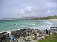
Harris
 Południowe Harris | |
| Kontynent | |
|---|---|
| Państwo | |
| Kraj | |
| Akwen | |
| Archipelag | |
| Powierzchnia | 401 km² |
| Populacja (2008) • liczba ludności • gęstość |
|
Położenie na mapie Hebrydów Zewnętrznych Contains Ordnance Survey data © Crown copyright and database right, CC BY-SA 3.0 | |
Położenie na mapie Szkocji | |
 | |
Harris (gael. Na Hearadh) – południowa część wyspy Lewis and Harris – największej w archipelagu Hebrydów Zewnętrznych, w Szkocji. Podobnie jak Lewis (północna część wyspy), region tradycyjnie nazywany jest „wyspą” Harris (Isle of Harris), choć są one ze sobą fizycznie połączone. Lewis jest generalnie niżej położoną częścią wyspy, podczas gdy Harris jest bardziej górzyste. Region należał dawniej do hrabstwa Inverness-shire, a obecnie, jak cały archipelag, należy do jednostki administracyjnej Hebrydy Zewnętrzne.
Harris dzieli się naturalnie na dwie części – północną i południową, oddzielone zatokami West Loch Tarbert i East Loch Tarbert, które połączone są wąskim przesmykiem, nad którym położona jest miejscowość Tarbert (An Tairbeart lub Tairbeart na Hearadh).
Pozostałe ważne miejscowości na Harris to Leverburgh, Hushinish i Rodel. Tarbert posiada stałe połączenie promowe z Uig na wyspie Skye. W spisie z 2001 roku Harris posiadało stałą populację 1984 mieszkańców[1].
Przypisy
- ↑ "Island Populations". cne-siar.gov.uk. [zarchiwizowane z tego adresu (2004-11-13)]. Comhairle nan Eilean Siar. Dodano 3 kwietnia 2008.
Media użyte na tej stronie
The flag of the United Kingdom (3:5 version). This flag is the Union Flag in the 3:5 ratio exclusively used on land. At sea, the correct ratio is 1:2.
Autor: Andrewrpalmer / Orionist, Licencja: CC BY-SA 3.0
Harris, the southern part of the Lewis and Harris island in the Outer Hebrides, Scotland.
(c) Eileen Henderson, CC BY-SA 2.0
Old Lazybeds
The grassy ridges are the remnants of lazybeds made by crofters for cultivating crops in the poor soil. South Harris can be seen across the Soay Sound, with Soay Mor and Soay Beag in between.
Autor: Alexrk2, Licencja: CC BY-SA 3.0
Location map of the United Kingdom
(c) Eric Gaba, NordNordWest, Uwe Dedering, CC BY-SA 3.0
Location map of Scotland, United Kingdom
Contains Ordnance Survey data © Crown copyright and database right, CC BY-SA 3.0
Relief map of the Outer Hebrides (excluding Sula Sgeir), UK.
Equirectangular map projection on WGS 84 datum, with N/S stretched 180%
Geographic limits:
- West: 8.70W
- East: 6.10W
- North: 58.60N
- South: 56.70N


