Hatton Cross
| ||
 Jedno z wejść na stację | ||
| Państwo | ||
| Kraj | ||
| Miejscowość | Londyn | |
| Data otwarcia | 1975 | |
| Piccadilly line | ||
| Poprzednia stacja | Hounslow West | |
| Następna stacja | Heathrow Terminals 1, 2, 3 lub Heathrow Terminal 4 | |
Położenie na mapie gminy Hillingdon  Contains Ordnance Survey data © Crown copyright and database right, CC BY-SA 3.0 | ||
Położenie na mapie Wielkiej Brytanii  (c) Karte: NordNordWest, Lizenz: Creative Commons by-sa-3.0 de | ||
Położenie na mapie Anglii  | ||
Położenie na mapie Wielkiego Londynu  Contains Ordnance Survey data © Crown copyright and database right, CC BY-SA 3.0 | ||
| Portal | ||
Hatton Cross – stacja metra londyńskiego obsługiwana przez linię Piccadilly, położona w bezpośrednim sąsiedztwie lotniska Heathrow, na terenie London Borough of Hillingdon. Została otwarta w 1975 roku i przez pierwsze dwa lata stanowiła jeden z krańców linii[1]. W roku 2009 skorzystało z niej ok. 2,715 mln pasażerów[2]. Jest stacją graniczną między piątą i szóstą strefą biletową[3].
Galeria
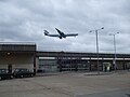
Samolot linii Cathay Pacific podchodzący do lądowania nad budynkiem stacji
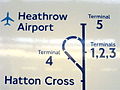
Hatton Cross na schemacie stacji obsługujących lotnisko Heathrow

Jeden z peronów

Logo stacji
Przypisy
- ↑ CULG - Piccadilly Line. [dostęp 2011-03-11].
- ↑ Statystyki Transport for London [dostęp 2011-03-11]
- ↑ Schemat sieci metra w Londynie [dostęp 2011-03-11]
| Linia główna |
|
|---|---|
| Odgałęzienie Uxbridge |
|
| Odgałęzienie Heathrow |
|
![]()
Media użyte na tej stronie
(c) Karte: NordNordWest, Lizenz: Creative Commons by-sa-3.0 de
Location map of the United Kingdom
Contains Ordnance Survey data © Crown copyright and database right, CC BY-SA 3.0
Map of Greater London, UK with the following information shown:
- Administrative borders
- Coastline, lakes and rivers
- Roads and railways
- Urban areas
The data includes both primary routes and railway lines.
Equirectangular map projection on WGS 84 datum, with N/S stretched 160%
Geographic limits:
- West: 0.57W
- East: 0.37E
- North: 51.72N
- South: 51.25N


Flag of England. Saint George's cross (a red cross on a white background), used as the Flag of England, the Italian city of Genoa and various other places.
Contains Ordnance Survey data © Crown copyright and database right, CC BY-SA 3.0
Blank map of the London Borough of Hillingdon, showing electoral wards.
Equirectangular map projection on WGS 84 datum, with N/S stretched 160%
Geographic limits:
- West: 0.53W
- East: 0.33W
- North: 51.64N
- South: 51.45N

A diagram of the London Underground Piccadilly Line at Heathrow Airport, including the Terminal 5 extension, open 2008. Photo of a sign at Ealing Common station.
Autor: Sunil060902, Licencja: CC BY-SA 3.0
Hatton Cross tube station southern entrance, on the Great South West Road (A30)


Autor: Sunil060902, Licencja: CC BY-SA 3.0
Hatton Cross tube station northern entrance adjacent to the bus stand. Note the airliner (Cathay Pacific Airbus A340) - whilst just outside the airport perimeter, the station is very close to the eastern end of Heathrow's southern runway.

Autor: Sunil060902, Licencja: CC BY-SA 3.0
Hatton Cross tube station platform roundel

Autor: Sunil060902, Licencja: CC BY-SA 3.0
Hatton Cross tube station westbound platform looking east