Havant (borough)
| dystrykt niemetropolitalny | |
(c) Basher Eyre, CC BY-SA 2.0 Havant | |
| Państwo | |
|---|---|
| Kraj | |
| Region | South East England |
| Hrabstwo | Hampshire |
| Siedziba | Havant |
| Powierzchnia | 55,3 km² |
| Populacja (2011) • liczba ludności | 120 684 |
| • gęstość | 2200 os./km² |
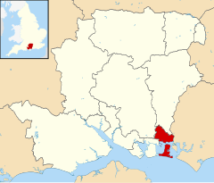
| Położenie na mapie Hampshire Contains Ordnance Survey data © Crown copyright and database right, CC BY-SA 3.0 | |
| Strona internetowa | |
| Portal | |
Havant – dystrykt w hrabstwie Hampshire w Anglii. W 2011 roku dystrykt liczył 120 684 mieszkańców[1].
Miasta
Inne miejscowości
Bedhampton, Cowplain, Ferry Point, Hart Plain, Northney, Purbrook, Stoke.
Przypisy
- ↑ Area: Havant (Local Authority) (ang.). Neighbourhood Statistics (ONS). [dostęp 2016-05-03]. [zarchiwizowane z tego adresu (2016-10-10)].
Media użyte na tej stronie
Flag of England. Saint George's cross (a red cross on a white background), used as the Flag of England, the Italian city of Genoa and various other places.
(c) Basher Eyre, CC BY-SA 2.0
Mini-roundabout in Havant town centre At the junction of North Street and Market Parade.
Contains Ordnance Survey data © Crown copyright and database right, CC BY-SA 3.0
Equirectangular map projection on WGS 84 datum, with N/S stretched 155%


