Hayling
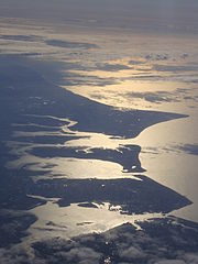
 Widok z lotu ptaka, od strony zachodniej – na dole miasto Gosport, dalej wyspy Portsea i Hayling oraz wcinający się w morze przylądek Selsey Bill | |
| Kontynent | Europa |
|---|---|
| Państwo | |
| Kraj | |
| Akwen | |
| Powierzchnia | 15,90 km² |
| Populacja (2011) • liczba ludności • gęstość |
|
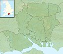
Położenie na mapie Hampshire Contains Ordnance Survey data © Crown copyright and database right, CC BY-SA 3.0 | |
 | |
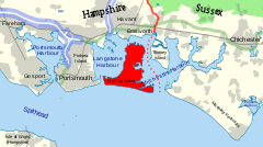
Hayling (ang. Hayling Island) – wyspa w południowej Anglii, w hrabstwie Hampshire, w dystrykcie Havant, położona u wybrzeża kanału La Manche, pomiędzy zatoką Langstone Harbour na zachodzie i Chichester Harbour na wschodzie[1].
Wyspa ma powierzchnię 15,90 km²[2]. W 2011 roku liczyła 17 379 mieszkańców[3][4]. Głównym skupiskiem ludności jest położone w południowej części wyspy miasto South Hayling. Ze stałym lądem wyspę łączy most drogowy, prowadzący na północ, w stronę miasta Havant. Prom pasażerski kursuje między Hayling a sąsiednią wyspą Portsea (część miasta Portsmouth)[1].
Wyspa jest ośrodkiem turystyki i uznawana jest za kolebkę windsurfingu[5].
Przypisy
- ↑ a b Mapa OS Explorer OL8, Ordnance Survey (ang.).
- ↑ Britain’s largest islands. Ordnance Survey Blog, 2018-06-28. [dostęp 2019-01-27]. (ang.).
- ↑ Hayling West Ward. Nomis. [dostęp 2019-01-28]. (ang.).
- ↑ Hayling East Ward. Nomis. [dostęp 2019-01-28]. (ang.).
- ↑ Hayling Island, Hampshire. Visit England. [dostęp 2019-01-27]. (ang.).
Media użyte na tej stronie
Autor: Alexrk2, Licencja: CC BY-SA 3.0
Location map of the United Kingdom
Flag of England. Saint George's cross (a red cross on a white background), used as the Flag of England, the Italian city of Genoa and various other places.
Locator map of Hayling Island, Hampshire, between Chichester Harbour and Langstone Harbour
Contains Ordnance Survey data © Crown copyright and database right, CC BY-SA 3.0
Relief map of Hampshire, UK.
Equirectangular map projection on WGS 84 datum, with N/S stretched 155%
Geographic limits:
- West: 2.01W
- East: 0.68W
- North: 51.41N
- South: 50.68N
Autor: JohnArmagh, Licencja: CC0
Photograph of Selsey Bill, Hayling Island and Portsea Island from the air
Autor: Nilfanion, Licencja: CC BY-SA 3.0
Relief map of England, UK.
Equirectangular map projection on WGS 84 datum, with N/S stretched 170%
Geographic limits:
- West: 6.75W
- East: 2.0E
- North: 56.0N
- South: 49.75N


