Hebburn
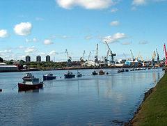
(c) Mike Ellison, CC BY-SA 2.0 | |
| Państwo | |
|---|---|
| Kraj | |
| Hrabstwo ceremonialne | Tyne and Wear |
| Unitary authority | South Tyneside |
| Populacja (2001) • liczba ludności | 18 808 |
| Nr kierunkowy | 0191 |
| Kod pocztowy | NE31 |
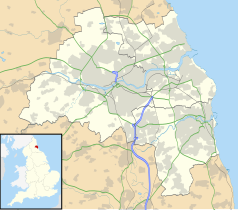
Położenie na mapie Tyne and Wear Contains Ordnance Survey data © Crown copyright and database right, CC BY-SA 3.0 | |
Położenie na mapie Wielkiej Brytanii (c) Karte: NordNordWest, Lizenz: Creative Commons by-sa-3.0 de | |
| Portal | |
Hebburn – miasto w północno-wschodniej Anglii, w hrabstwie ceremonialnym Tyne and Wear, w dystrykcie (unitary authority) South Tyneside, część aglomeracji Tyneside. Położone jest na południowym brzegu rzeki Tyne, około 7 km na wschód od centrum Newcastle i 396 km na północ od Londynu[1]. W 2001 miasto liczyło 18 808 mieszkańców.
Przypisy
- ↑ Hebburn na mapie (ang.). getamap.ordnancesurvey.co.uk. [dostęp 2010-11-27].
Media użyte na tej stronie
(c) Karte: NordNordWest, Lizenz: Creative Commons by-sa-3.0 de
Location map of the United Kingdom
Flag of England. Saint George's cross (a red cross on a white background), used as the Flag of England, the Italian city of Genoa and various other places.
Contains Ordnance Survey data © Crown copyright and database right, CC BY-SA 3.0
Map of Tyne and Wear, UK, with the following information shown:
- Administrative borders
- Coastline, lakes and rivers
- Roads and railways
- Urban areas
Equirectangular map projection on WGS 84 datum, with N/S stretched 170%
Geographic limits:
- West: 1.90W
- East: 1.30W
- North: 55.09N
- South: 54.78N
(c) Mike Ellison, CC BY-SA 2.0
Hebburn Riverside Looking downriver from near the Bill Quay bend (behind the camera) with the cranes of Swan Hunter shipyard, Wallsend on the opposite bank. Sadly this great yard ceased operation in 2006 and the iconic cranes were sold in early 2007.


