Heeze-Leende
| |||||
 | |||||
| Państwo | |||||
| Prowincja | |||||
| Burmistrz | Paul Verhoeven (2014)[1] | ||||
| Powierzchnia | 105,04 km² | ||||
| Populacja (2014) • liczba ludności • gęstość | 15 376[2] 148 os./km² | ||||
| Nr kierunkowy | 040 | ||||
| Kod pocztowy | 5590-5595, 6029 | ||||
| Strona internetowa | |||||
Heeze-Leende – gmina w prowincji Brabancja Północna w Holandii. W 2014 roku zamieszkiwało ją 15 376 mieszkańców. Gmina powstała 1 stycznia 1997 roku z połączenia Heeze (9650 mieszk.) i Lende (4300 mieszk.) oraz wsi Sterksel (1320 mieszk.). Stolicą gminy jest Heeze.
Miejscowości w gminie
Bruggerhuizen, Euvelwegen, Heeze (stolica), Heezerenbosch, Kerkhof, Kreijl, Leende, Leenderstrijp, Oosterik, Rul, Sterksel, Ginderover, Strabrecht en Ven.
Przez gminę przechodzą autostrady A2 oraz A67.
Przypisy
- ↑ heeze-leende.nl: Burgemeester en wethouder op bezoek bij Providentia(29-07-2013) (niderl.). [dostęp 2014-07-13]. [zarchiwizowane z tego adresu (2014-07-14)].
- ↑ Aktualna liczba mieszkańców miasta (nl) [dostęp 18 kwietnia 2014]
Media użyte na tej stronie
Autor: Erik Frohne, Licencja: CC BY-SA 3.0
Location map of province North Brabant in the Netherlands
Equirectangular projection, N/S stretching 161 %. Geographic limits of the map:
- N: 51.90° N
- S: 51.20° N
- W: 4.10° E
- E: 6.10° E
Autor: G.Lanting, Licencja: CC BY-SA 3.0
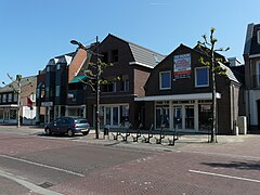
Zicht op winkels in een deel van de Jan Deckersstraat in Heeze
Coat of arms of the Dutch municipality of Heeze-Leende.
Vlag of Heeze-Leende (Netherlands)


