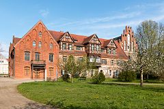
Heiligengrabe
| gmina | |||
(c) Dietmar Rabich, CC BY-SA 4.0 | |||
| |||
| Państwo | |||
|---|---|---|---|
| Kraj związkowy | |||
| Powiat | Ostprignitz-Ruppin | ||
| Powierzchnia | 206,31 km² | ||
| Wysokość | 75 m n.p.m. | ||
| Populacja (31.12.2008) • liczba ludności | 4 862 | ||
| • gęstość | 24 os./km² | ||
| Numer kierunkowy | 033962 | ||
| Kod pocztowy | 16909, 16928 | ||
| Tablice rejestracyjne | OPR, KY, NP, WK | ||
Adres urzędu: Am Birkenwäldchen 1a16909 Heiligengrabe | |||
Położenie na mapie powiatu | |||
| 53°09′N 12°21′E/53,150000 12,350000 | |||
| Strona internetowa | |||
| Portal | |||
Heiligengrabe – gmina w Niemczech w kraju związkowym Brandenburgia, w powiecie Ostprignitz-Ruppin.
Geografia
Gmina Heiligengrabe położona jest pomiędzy miastami Wittstock/Dosse i Pritzwalk.
Dzielnice
W skład gminy wchodzą następujące dzielnice:
|
|
Współpraca
Galeria
Media użyte na tej stronie
Autor: Doris Antony, Berlin, Licencja: CC BY-SA 3.0
Former vocational school in Blumenthal-Horst (municipality Heiligengrabe) in Brandenburg, Germany
Autor: Doris Antony, Berlin, Licencja: CC BY-SA 3.0
Herb garden, Convent building and Blood Chapel of Heiligengrabe Abbey in Heiligengrabe in Brandenburg, Germany
Autor: own work by Geograv, Licencja: CC-BY-SA-3.0
Heiligengrabe in Brandenburg (Country) - District Ostprignitz-Ruppin
Autor: Doris Antony, Berlin, Licencja: CC BY-SA 3.0
Manor house in Heiligengrabe-Maulbeerwalde in Brandenburg, Germany
Autor: Doris Antony, Berlin, Licencja: CC BY-SA 3.0
Manor house in Heiligengrabe-Grabow in Brandenburg, Germany
(c) Dietmar Rabich, CC BY-SA 4.0
This is a picture of the Brandenburger Baudenkmal (cultural heritage monument) with the ID


