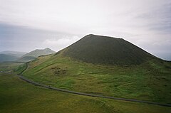
Helgafell
 Wulkan Helgafell | |
| Państwo | |
|---|---|
| Położenie | |
| Wysokość | 73 m n.p.m. |
Helgafell lub Helgafjell (holy mountain – święta góra) – wygasły (ostatnia erupcja ok. 6000 lat temu) wulkan (73 m n.p.m.) położony na islandzkiej wyspie Heimaey w pobliżu aktywnego wulkanu Eldfell.
Linki zewnętrzne
- Helgafell. nat.is. [zarchiwizowane z tego adresu (2009-01-24)].
Media użyte na tej stronie
Black up-pointing triangle ▲, U+25B2 from Unicode-Block Geometric Shapes (25A0–25FF)
Autor: Autor nie został podany w rozpoznawalny automatycznie sposób. Założono, że to לערי ריינהארט (w oparciu o szablon praw autorskich)., Licencja: CC BY 2.5
Helgafell in Helgafellssveit Iceland
Autor: Clem23, Licencja: CC BY-SA 3.0
Helgafell volcano in Heimaey seen from the top of Eldfell, Vestmann Islands, Iceland.
Autor: en:User:Worldtraveller, Licencja: CC-BY-SA-3.0
The island of Heimaey, with Helgafell at the left and Eldfell on the right. The extent of the 1973 eruption fissure south of Eldfell is visible.
Autor:
- Iceland_location_map.svg: NordNordWest
- derivative work: Виктор В (talk)
Location map of Iceland


