Hereford
 Centrum miasta | |||
| |||
| Państwo | |||
|---|---|---|---|
| Kraj | |||
| Region | |||
| Hrabstwo ceremonialne | |||
| Unitary authority | |||
| Populacja (2011) • liczba ludności |
| ||
| Nr kierunkowy | 01432 | ||
| Kod pocztowy | HR1 | ||
Położenie na mapie Herefordshire  Contains Ordnance Survey data © Crown copyright and database right, CC BY-SA 3.0 | |||
Położenie na mapie Wielkiej Brytanii  (c) Karte: NordNordWest, Lizenz: Creative Commons by-sa-3.0 de | |||
Położenie na mapie Anglii  | |||
| Strona internetowa | |||
| Portal | |||
Hereford – miasto i civil parish[1] w Wielkiej Brytanii, w Anglii, w hrabstwie ceremonialnym Herefordshire, położone w pobliżu granicy z Walią, nad rzeką Wye. W 2011 roku civil parish liczyła 53 516 mieszkańców[2].
Hereford to typowe miasteczko rolnicze (nazwę „Hereford” nosi rasa bydła mięsnego[3]). Miasto to znajduje się około 26 km na wschód od granicy Walii i 37 km na zachód od miasta Worcester.
Miasto wspomniane zostało w Domesday Book (1086)[4]. W mieście znajduje się katedra zbudowana w 1079 roku. W katedrze znajduje się największa znana mapa średniowieczna, tzw. mapa z Hereford (mappa mundi), z ok. 1300 roku.
W Hereford swoją kwaterę główną ma elitarna brytyjska jednostka specjalna Special Air Service.
W 1978 Hereford odbyły się pierwsze żużlowe Mistrzostwa Europy na torze trawiastym.
W mieście rozwinął się przemysł metalowy, spożywczy, meblarski, szklarski oraz skórzany[5].
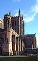
Katedra w Hereford

Katedra i rzeka Wye
Współpraca
Przypisy
- ↑ Ordnance Survey linked data
- ↑ Neighbourhood Statistics
- ↑ Bydło rasy Hereford. W: Strona internetowa Zakładu Doświadczalnego Instytutu Zootechniki PIB Odrzechowa [on-line]. ZDIZ. [dostęp 2017-04-29].
- ↑ The Domesday Book online
- ↑ Hereford, [w:] Encyklopedia PWN [online] [dostęp 2021-09-30].
Media użyte na tej stronie
(c) Karte: NordNordWest, Lizenz: Creative Commons by-sa-3.0 de
Location map of the United Kingdom


Flag of England. Saint George's cross (a red cross on a white background), used as the Flag of England, the Italian city of Genoa and various other places.

.svg)
Autor: Rwendland, Licencja: CC BY-SA 3.0
Hereford, High Street pedestrian shopping area, also known as High Town.

(c) Ruth Harris, CC BY-SA 2.0
Hereford Cathedral, England at grid reference SO509397. There has been a church near this site since at least the 8th century. The current (Norman) Cathedral was originally built in the 12th century in the Romanesque style and much of it is still standing. The early cathedral was somewhat closer to the river. The current cathedral is built on the site of the Saxon market, according to an early map in the book, A Slap of the Hand -The History of Hereford Market, published by Hereford Lore.

Autor: KGGucwa, Licencja: CC BY-SA 3.0
Hereford, England. The cathedral and the river Wye as in May 1991.
Contains Ordnance Survey data © Crown copyright and database right, CC BY-SA 3.0
Map of Herefordshire, UK with the following information shown:
- Administrative borders
- Coastline, lakes and rivers
- Roads and railways
- Urban areas
Equirectangular map projection on WGS 84 datum, with N/S stretched 160%
Geographic limits:
- West: 3.15W
- East: 2.33W
- North: 52.45N
- South: 51.80N
.png)
Autor: Rs-nourse, Licencja: CC BY-SA 4.0
"The ancient coat of arms of the City of Hereford were Gules, three lions passant guardant in pale argent. But, after the brave and successful defence of the City against the Scots and the Earl of Leven, Charles I. granted an honourable augmentation of the arms, dated 16 Sept. 1645 - Gules, three lions passant guardant in pale argent, on a bordure azure ten saltires of the 2nd." (Strong)
- Strong, George (1848) The Heraldry of Herefordshire: Being a Collection of the Armorial Bearings of Families Which Have Been Seated in the County at Various Periods Down to the Present Time., Londyn: Churton Press