Hereford and Worcester
| byłe hrabstwo | |||
| 1974-1998 | |||
 | |||
| |||
| Państwo | |||
|---|---|---|---|
| Kraj | |||
| Plan | |||
Położenie na mapie | |||
| Portal | |||
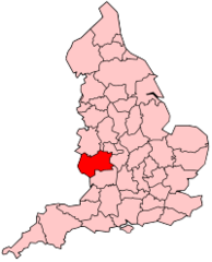
Hereford and Worcester – dawne hrabstwo administracyjne (niemetropolitalne) w Anglii, istniejące od 1 kwietnia 1974 do 1 kwietnia 1998, powstałe z połączenia hrabstw Herefordshire i Worcestershire[1].
Podział administracyjny
Hrabstwo Hereford and Worcester podzielone było na sześć dystryktów:
- Wyre Forest
- Bromsgrove
- Redditch
- Wychavon
- Worcester
- Malvern Hills
- Leominster
- Hereford
- South Herefordshire
Przypisy
- ↑ Registration Districts in Hereford & Worcester. UKBMD. [dostęp 2016-03-02]. (ang.).
Media użyte na tej stronie
Flag of England. Saint George's cross (a red cross on a white background), used as the Flag of England, the Italian city of Genoa and various other places.
(c) Keith Edkins z angielskojęzycznej Wikipedii, CC-BY-SA-3.0
Districts in the former County of Hereford and Worcester (1974-1998)
- Wyre Forest
- Bromsgrove
- Redditch
- Wychavon
- Worcester
- Malvern Hills
- Leominster
- Hereford
- South Herefordshire
Autor: Original uploader was Morwen at en.wikipedia, Licencja: CC-BY-SA-3.0
Former administrative county of England
Autor: Antbex74, Licencja: CC BY-SA 4.0
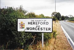
County of Hereford and Worcester sign on the A449 road on the boundary near Caunsall between Worcestershire and Staffordshire. Hereford and Worcester was dissolved in 1998, three years after this photograph was taken.


