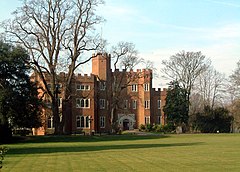
Hertford
| ||
 Hertford Castle | ||
| Państwo | ||
| Kraj | ||
| Region | East of England | |
| Hrabstwo | Hertfordshire | |
| Powierzchnia | 30,9 km² | |
| Populacja (2001) • liczba ludności | 24 180 | |
| Nr kierunkowy | 01992 | |
| Kod pocztowy | SG13, SG14 | |
Położenie na mapie Hertfordshire Contains Ordnance Survey data © Crown copyright and database right, CC BY-SA 3.0 | ||
Położenie na mapie Wielkiej Brytanii (c) Karte: NordNordWest, Lizenz: Creative Commons by-sa-3.0 de | ||
| Strona internetowa | ||
| Portal | ||
Hertford – miasto w Wielkiej Brytanii, w Anglii, położone na północ od Londynu, nad rzeką Lea. Ośrodek administracyjny hrabstwa Hertfordshire.
W 2001 roku liczba mieszkańców wynosiła 24 180.
Ośrodek handlowy. Przemysł elektrotechniczny.
Komunikacja
- W Hertford znajdują się dwie stacje kolejowe: Hertford East i Hertford North. Obie oferują połączenia do Londynu.
- Droga krajowa A414 łączy miasto z Harlow, autostradą M11 i Chelmsford na wschodzie i Hatfield, drogą krajową A1 i dalej M1 na zachodzie. Także tuż za Hertford przebiega droga krajowa A10, łącząca miasto z Londynem na południu i Cambridge na północy.
- W centrum miasta znajduje się dworzec autobusowy, oferujący połączenia do Bishop's Stortford, Waltham Cross, St. Albans, Royston, Stevenage i Heathrow
Miasta partnerskie
Media użyte na tej stronie
(c) Karte: NordNordWest, Lizenz: Creative Commons by-sa-3.0 de
Location map of the United Kingdom
Flag of England. Saint George's cross (a red cross on a white background), used as the Flag of England, the Italian city of Genoa and various other places.
The flag of Navassa Island is simply the United States flag. It does not have a "local" flag or "unofficial" flag; it is an uninhabited island. The version with a profile view was based on Flags of the World and as a fictional design has no status warranting a place on any Wiki. It was made up by a random person with no connection to the island, it has never flown on the island, and it has never received any sort of recognition or validation by any authority. The person quoted on that page has no authority to bestow a flag, "unofficial" or otherwise, on the island.
Autor: Caitlin from Hertfordshire, UK, Licencja: CC BY 2.0
The main castle entrance built by Edward IV in 1463-5, since extended by sections built in the late 1700's and as recently as 1936/7. Now offices of the the Town Council.
Contains Ordnance Survey data © Crown copyright and database right, CC BY-SA 3.0
Map of Hertfordshire, UK with the following information shown:
- Administrative borders
- Coastline, lakes and rivers
- Roads and railways
- Urban areas
Equirectangular map projection on WGS 84 datum, with N/S stretched 160%
Geographic limits:
- West: 0.80W
- East: 0.35E
- North: 52.09N
- South: 51.59N


