Hertfordshire
| Hrabstwo ceremonialne i niemetropolitalne | |||||
 Hatfield House | |||||
| |||||
| Państwo | |||||
|---|---|---|---|---|---|
| Kraj | |||||
| Region | |||||
| Siedziba | |||||
| Powierzchnia | 1643 km² | ||||
| Populacja (2011) • liczba ludności |
| ||||
| • gęstość | 679,2 os./km² | ||||
| Szczegółowy podział administracyjny | |||||
 | |||||
| Liczba dystryktów | 10 | ||||
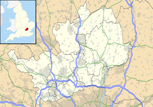
Położenie na mapie | |||||
| Strona internetowa | |||||
| Portal | |||||
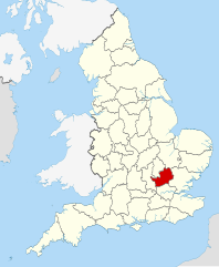
Hertfordshire (skrótowo Herts) – hrabstwo administracyjne (niemetropolitalne), ceremonialne i historyczne we wschodniej Anglii, w regionie East of England, położone na północ od Londynu, będące jednym z tzw. Home Counties.
Powierzchnia hrabstwa wynosi 1643 km², a liczba ludności – 1 116 000 mieszkańców (2011)[1]. Ośrodkiem administracyjnym hrabstwa jest Hertford, największym miastem Watford, a jedynym miastem posiadającym status city – St Albans. Innymi większymi miastami na terenie hrabstwa są Hemel Hempstead, Stevenage, Welwyn Garden City, Cheshunt oraz Hoddesdon[2].
Południowa część hrabstwa leży na obszarze Basenu Londyńskiego, a przez północną przebiega pasmo wzgórz Chiltern Hills.
Na zachodzie Hertfordshire graniczy z hrabstwem Buckinghamshire, na północy z Bedfordshire, na północnym wschodzie z Cambridgeshire, na wschodzie z Essex, a na południu z regionem Wielkiego Londynu.
Podział administracyjny
W skład hrabstwa wchodzi dziesięć dystryktów.
- Three Rivers
- Watford
- Hertsmere
- Welwyn Hatfield
- Broxbourne
- East Hertfordshire
- Stevenage
- North Hertfordshire
- City of St. Albans
- Dacorum
Mapa
Przypisy
- ↑ Table P04 2011 Census: Usual resident population by five-year age group, local authorities in England and Wales. Office for National Statistics. [dostęp 2012-07-24]. (ang.).
- ↑ a b Office for National Statistics: KS101EW - Usual resident population. [w:] 2011 Census [on-line]. Nomis – Official labour market statistics, 2013-02-12. [dostęp 2022-06-05]. (ang.).
- ↑ Office for National Statistics: Built-up Area to Local Authority District (December 2011) Lookup in England and Wales. [w:] Open Geography Portal [on-line]. [dostęp 2022-06-05]. (ang.).
- ↑ Office for National Statistics: Built-up Area Sub Divisions (December 2011) Boundaries. [w:] Open Geography Potal [on-line]. [dostęp 2022-06-05]. (ang.).
Bibliografia
- Hertfordshire, [w:] Encyclopædia Britannica [online] [dostęp 2012-05-10] (ang.).
Media użyte na tej stronie
Flag of England. Saint George's cross (a red cross on a white background), used as the Flag of England, the Italian city of Genoa and various other places.
Hertfordshire flag. The county flag of Hertfordshire registered by the Flag Institute
Contains Ordnance Survey data © Crown copyright and database right, CC BY-SA 3.0
Map of Hertfordshire, UK with the following information shown:
- Administrative borders
- Coastline, lakes and rivers
- Roads and railways
- Urban areas
Equirectangular map projection on WGS 84 datum, with N/S stretched 160%
Geographic limits:
- West: 0.80W
- East: 0.35E
- North: 52.09N
- South: 51.59N
Autor: Nilfanion, Licencja: CC BY-SA 3.0
Location of the ceremonial county of Hertfordshire within England.
Autor: Allan Engelhardt, Licencja: CC BY-SA 2.0
Hatfield House, Hertfordshire, England.


