Het Steen
 | |
| Państwo | |
|---|---|
| Miejscowość | Antwerpia |
| Rozpoczęcie budowy | 1200 |
| Ukończenie budowy | 1225 |
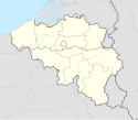
Położenie na mapie Belgii (c) Karte: NordNordWest, Lizenz: Creative Commons by-sa-3.0 de | |
Het Steen – średniowieczny zamek w Antwerpii (Belgia). Wybudowany w latach 1200-1225, jest najstarszym budynkiem w mieście.
Media użyte na tej stronie
Belgium adm location map.svg
(c) Karte: NordNordWest, Lizenz: Creative Commons by-sa-3.0 de
Location map of Belgium
(c) Karte: NordNordWest, Lizenz: Creative Commons by-sa-3.0 de
Location map of Belgium
Legenda zamek.svg
Symbol zamku do legendy mapy
Symbol zamku do legendy mapy
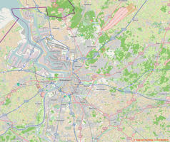
Groot-Antwerpen.png
Autor: Contributors of OpenStreetMap, Licencja: CC BY-SA 2.0
Map of Greater Antwerp area
Autor: Contributors of OpenStreetMap, Licencja: CC BY-SA 2.0
Map of Greater Antwerp area
Geographic limits of the map:
- N 51.393°
- W 4.178°
- E 4.756°
- Z 51.089°
Belgium Antwerp location map.svg
Autor: Milenioscuro, Licencja: CC BY-SA 3.0
Location map of Antwep province, Belgium
Autor: Milenioscuro, Licencja: CC BY-SA 3.0
Location map of Antwep province, Belgium
0 Het Steen - Antwerpen (1).JPG
Autor: Jean-Pol GRANDMONT, Licencja: CC BY-SA 3.0
This is a photo of onroerend erfgoed number
Autor: Jean-Pol GRANDMONT, Licencja: CC BY-SA 3.0
This is a photo of onroerend erfgoed number


