Highgate (Londyn)
| ||||
| ||||
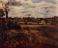
 Widok Highgate, John Constable | ||||
| Państwo | ||||
| Kraj | ||||
| Region | Wielki Londyn | |||
| Miasto | Londyn | |||
Położenie na mapie Wielkiego Londynu Contains Ordnance Survey data © Crown copyright and database right, CC BY-SA 3.0 | ||||
| Portal | ||||
Highgate – dzielnica północnego Londynu, której fragmenty wchodzą w skład trzech dzielnic administracyjnych: Haringey, Camden i Islington.
Interesujące miejsca
- Highgate Cemetery
- Highgate School
- Highgate Wood
- Kenwood House
W pobliżu
- Finchley
- Hampstead
- Muswell Hill
- Dartmouth Park
- Tufnell Park
- Kentish Town
- Holloway
- Crouch End
Stacje metra
Linki zewnętrzne
Media użyte na tej stronie
Contains Ordnance Survey data © Crown copyright and database right, CC BY-SA 3.0
Map of Greater London, UK with the following information shown:
- Administrative borders
- Coastline, lakes and rivers
- Roads and railways
- Urban areas
The data includes both primary routes and railway lines.
Equirectangular map projection on WGS 84 datum, with N/S stretched 160%
Geographic limits:
- West: 0.57W
- East: 0.37E
- North: 51.72N
- South: 51.25N
Autor: NordNordWest, Licencja: CC BY-SA 3.0
Location map of the United Kingdom
Flag of England. Saint George's cross (a red cross on a white background), used as the Flag of England, the Italian city of Genoa and various other places.
Autor: http://en.wikipedia.org/wiki/User:Burn_the_asylum, Licencja: CC-BY-SA-3.0
Karl Marx Tomb in London (Karl Marx Mezar Taşı - Londra)


