Highgrove
(c) Robin Webster, CC BY-SA 2.0 | |
| Państwo | |
|---|---|
| Kraj | |
| Miejscowość | Doughton |
| Typ budynku | wiejska rezydencja królewska |
| Architekt | Anthony Keck |
| Rozpoczęcie budowy | |
| Ukończenie budowy | |
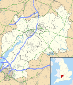
Położenie na mapie Gloucestershire Contains Ordnance Survey data © Crown copyright and database right, CC BY-SA 3.0 | |
Położenie na mapie Wielkiej Brytanii (c) Karte: NordNordWest, Lizenz: Creative Commons by-sa-3.0 de | |
| Strona internetowa | |
Highgrove - rezydencja księcia Walii Karola, znajdująca się w Gloucestershire w Anglii.
Zbudowana w latach 1796-1798 prawdopodobnie na podstawie projektu Anthony'ego Kecka. W 1894 przebudowana po pożarze. W 1980 kupiona przez księstwo Kornwalii. Od 1981 rezydencja księcia Walii Karola i księżnej Walii Diany. Diana wyprowadziła się z Highgrove po rozpadzie jej małżeństwa z Karolem.
Rezydencję otaczają lasy i ziemie uprawne. Uprawy są organiczne.
Linki zewnętrzne
- Highrove na oficjalnej stronie księcia Walii. princeofwales.gov.uk. [zarchiwizowane z tego adresu (2012-04-02)].
Media użyte na tej stronie
(c) Karte: NordNordWest, Lizenz: Creative Commons by-sa-3.0 de
Location map of the United Kingdom
Blue Shield - the Distinctive emblem for the Protection of Cultural Property. The distinctive emblem is a protective symbol used during armed conflicts. Its use is restricted under international law.
Flag of England. Saint George's cross (a red cross on a white background), used as the Flag of England, the Italian city of Genoa and various other places.
Contains Ordnance Survey data © Crown copyright and database right, CC BY-SA 3.0
Map of Gloucestershire, UK with the following information shown:
- Administrative borders
- Coastline, lakes and rivers
- Roads and railways
- Urban areas
Equirectangular map projection on WGS 84 datum, with N/S stretched 160%
Geographic limits:
- West: 2.70W
- East: 1.60W
- North: 52.16N
- South: 51.36N
Autor: Praca własna, Licencja: CC-BY-SA-3.0
Queen Elizabeth II's personal flag (1960)


