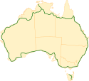
Highway 1 (Australia)
Highway 1 - szlak drogowy o łącznej długości 14 500 km, przebiegający dookoła Australii. Łączy ze sobą wszystkie stolice stanów.
Ze względu na swoją długość i system zarządzania, podzielona jest na sekcje wchodzące w skład systemu National Highway i posiadający swoje indywidualne nazwy własne[1][2].
Drogi wchodzące w skład Highway 1
- Princes Highway
- Port Wakefield Road
- Eyre Highway
- Coolgardie-Esperance Highway
- South Coast Highway
- South Western Highway
- Brand Highway
- North West Coastal Highway
- Victoria Highway
- Stuart Highway
- Carpentaria Highway
- Savannah Way
- Gulf Developmental Road
- Bruce Highway
- Pacific Highway
- Brooker Highway
- Midland Highway
- Bass Highway
Mapy
Przypisy
- ↑ Roads, www.infrastructure.gov.au [dostęp 2017-11-23] (ang.).
- ↑ Australia's Highway 1
Media użyte na tej stronie
Sign no. 392 - Customs, darker version
prom rzeka-icon.
(Motorway) tunnel Icon. Drawing similar to Swiss road signs.
Gas station symbol
AIGA Air Transportation sign (inverted)
The flag of the Northern Territory (adopted on July 1, 1978 on the first day of self-government) was designed by the Australian artist Robert Ingpen, of Drysdale Victoria, after consultation with members of the community at the invitation of the Northern Territory Government. The flag incorporates the three official Territorian colours of black, white and ochre and is divided into two panels, black at the hoist side taking up one third the length of the flag while the remainder is equal to two third the length of the flag in ochre. The black panel display the five white stars that form the constellation of the Southern Cross, using the Victorian configuration of the Southern Cross with stars having between five to eight points. The flag also features the official Northern Territory floral emblem on the red ochre panel, a stylisation of the Sturt's Desert Rose, which uses seven petals encircling a seven-pointed black star of the federation in the centre. The seven petals symbolises the six Australian states plus the Northern Territory. The Northern Territory Flag was the first official flag that did not contain the Union Jack.
Map of Australia's Highway 1
Autor: Cgoodwin, Licencja: CC BY-SA 3.0
The southbound Hexham Bridge on the Pacific Highway in New South Wales, Australia, is the largest of few surviving lift span bridges in New South Wales and is still in working order. The bridge, which is one of two bridges over the Hunter River at this point, is seen from the northern approach in Tomago, New South Wales. Both of the Hexham bridges are actually in the suburb of Tarro, while the northern and southern approaches are in Tomago and Hexham respectively.NSW Department of Lands - Spatial Information Exchange
Image of an Australian Route 1 shield.


