Hinckley and Bosworth
| dystrykt niemetropolitalny | |
 Hinckley | |
| Państwo | |
|---|---|
| Kraj | |
| Region | |
| Hrabstwo | |
| Siedziba | Hinckley |
| Powierzchnia | 297 km² |
| Populacja (2021) • liczba ludności |
|
| • gęstość | 382,5 os./km² |
| Położenie na mapie Leicestershire Contains Ordnance Survey data © Crown copyright and database right, CC BY-SA 3.0 | |
| Strona internetowa | |
| Portal | |
Hinckley and Bosworth – dystrykt w hrabstwie Leicestershire w Anglii.
Miasta
- Earl Shilton
- Hinckley
- Market Bosworth
Inne miejscowości
Barlestone, Barwell, Burbage, Cadeby, Groby, Higham on the Hill, Markfield, Nailstone, Osbaston, Peckleton, Ratby, Shackerstone, Stanton under Bardon, Stoke Golding, Sutton Cheney, Thornton, Twycross, Witherley.
Przypisy
- ↑ Population and household estimates, England and Wales: Census 2021, www.ons.gov.uk [dostęp 2017-10-22] (ang.).
Media użyte na tej stronie
Flag of England. Saint George's cross (a red cross on a white background), used as the Flag of England, the Italian city of Genoa and various other places.
Contains Ordnance Survey data © Crown copyright and database right, CC BY-SA 3.0
Map of Leicestershire, UK with Hinckley and Bosworth highlighted.
Equirectangular map projection on WGS 84 datum, with N/S stretched 160%Autor: Crazeman, Licencja: CC BY-SA 3.0
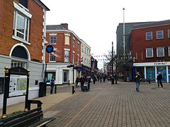
A photograph of Hinckley town centre, showing part of Market Place and Castle Street on a weekday morning. Taken on Tuesday 11th April, 2013.


