Hinterstoder
 | |||
| |||
| Państwo | |||
|---|---|---|---|
| Kraj związkowy | |||
| Powiat | Kirchdorf an der Krems | ||
| Powierzchnia | 149,09 km² | ||
| Wysokość | 591 m n.p.m. | ||
| Populacja (1 stycznia 2015) • liczba ludności | 900 | ||
| • gęstość | 6 os./km² | ||
| Numer kierunkowy | 07564 | ||
| Kod pocztowy | 4573 | ||
| Tablice rejestracyjne | KI | ||
| Strona internetowa | |||
Hinterstoder – miejscowość i gmina w Austrii, położona w kraju związkowym Górna Austria, w powiecie Kirchdorf an der Krems, w paśmie górskim Totes Gebirge. Jest znaną bazą narciarską, ośrodkiem sportowym i turystycznym. Gmina składa się z czterech blisko położonych miejscowości: Hinterberg, Hinterstoder, Mitterstoder, Vordertambergau. Liczy 900 mieszkańców[1].
Czasem odbywają się tu zawody Pucharu Świata w narciarstwie alpejskim.
Galeria
Linki zewnętrzne
Przypisy
Media użyte na tej stronie
Autor: Lencer, Licencja: CC BY-SA 3.0
Location map of Austria
Equirectangular projection, N/S stretching 150 %. Geographic limits of the map:
- N: 49.2° N
- S: 46.3° N
- W: 9.4° E
- E: 17.2° E
Autor: Herzi Pinki, Licencja: CC BY-SA 3.0
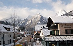
Main road in Hinterstoder, Upper Austria. In the background the mountains Ostrawitz (1823m) and Spitzmauer (2446m).
Autor: Herzi Pinki, Licencja: CC BY-SA 3.0
Hutterer Böden in the skiing area of Hutterer Höss in Hinterstoder, Upper Austria. See annotations for details.
Autor: Rosso Robot, Licencja: CC BY-SA 3.0
Location map of Upper Austria
Equirectangular projection. Geographic limits of the map:
- N: 48.78063° N
- S: 47.44388° N
- W: 12.73041° E
- E: 15.00183° E
Autor: Stemonitis, Licencja: CC BY-SA 2.5
Großer Priel, mountain in Totes Gebirge in Austria


