Hochfrottspitze
| ||
 | ||
| Państwo | ||
| Położenie | Bawaria | |
| Pasmo | Alpy Algawskie | |
| Wysokość | 2649 m n.p.m. | |
| Pierwsze wejście | 1869 Hermann von Barth | |
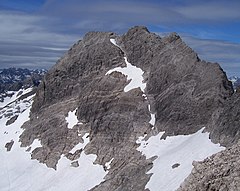
Hochfrottspitze – szczyt w Alpach Algawskich, części Alp Bawarskich. Leży na granicy między Austrią (Tyrol), a Niemcami (Bawaria). Trzeci co do wysokości szczyt Alp Algawskich. Sąsiaduje z Trettachspitze i Mädelegabel. Jest najwyższym szczytem niemieckiej części Alp Algawskich.
Pierwszego wejścia, w 1869 r., dokonał Hermann von Barth.
Bibliografia
- Thaddäus Steiner: Allgäuer Bergnamen, Lindenberg, Kunstverlag Josef Fink, 2007, ISBN 978-3-89870-389-5
- Thaddäus Steiner: Die Flurnamen der Gemeinde Oberstdorf im Allgäu, München, Selbstverlag des Verbandes für Flurnamenforschung in Bayern, 1972
- Dieter Seibert: Allgäuer Alpen Alpin, Alpenvereinsführer. München, Bergverlag Rudolf Rother 2004. ISBN 3-7633-1126-2
- Alpenvereinskarte 1:25.000, Blatt 2/1, Allgäuer- Lechtaler Alpen, West
Media użyte na tej stronie
Autor: Rosso Robot, Licencja: CC BY-SA 3.0
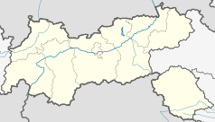
Location map of The Tyrol
Equirectangular projection. Geographic limits of the map:
- N: 47.75317° N
- S: 46.64119° N
- W: 10.08236° E
- E: 12.98961° E
Autor: Uwe Dedering, Licencja: CC BY-SA 3.0
Location map of Austria
Equirectangular projection, N/S stretching 150 %. Geographic limits of the map:
- N: 49.2° N
- S: 46.3° N
- W: 9.4° E
- E: 17.2° E
Black up-pointing triangle ▲, U+25B2 from Unicode-Block Geometric Shapes (25A0–25FF)
Autor: Frstgr, Licencja: CC BY-SA 3.0
Hochfrottspitze viewed from the ascend to the Mädelegabel


