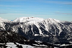
Hoher Nock
 | |
| Państwo | |
|---|---|
| Położenie | |
| Pasmo | Alpy Górnoaustriackie |
| Wysokość | 1963[1] m n.p.m. |
Hoher Nock[1] - najwyższy szczyt pasma górskiego Oberösterreichische Voralpen, będącego częścią Północnych Alp Wapiennych. Leży w Austrii, w kraju związkowym Górna Austria.
Przypisy
- ↑ a b BEV - Austrian Map online. [dostęp 2014-07-21].
Bibliografia
- Hoher Nock. geomix.at. [zarchiwizowane z tego adresu (2009-08-03)].
Media użyte na tej stronie
Black up-pointing triangle ▲, U+25B2 from Unicode-Block Geometric Shapes (25A0–25FF)
Autor: Rosso Robot, Licencja: CC BY-SA 3.0
Location map of Upper Austria
Equirectangular projection. Geographic limits of the map:
- N: 48.78063° N
- S: 47.44388° N
- W: 12.73041° E
- E: 15.00183° E
Autor: Uwe Dedering, Licencja: CC BY-SA 3.0
Location map of Austria
Equirectangular projection, N/S stretching 150 %. Geographic limits of the map:
- N: 49.2° N
- S: 46.3° N
- W: 9.4° E
- E: 17.2° E
Autor: Herzi Pinki, Licencja: CC BY-SA 3.0
Hoher Nock (1963m), a mountain in the Sengsengebirge in Upper Austria, as seen from Hutterer Höss heading NE.


