Hollymount
| ||
(c) Paul Anderson, CC BY-SA 2.0 Szkoła podstawowa w Hollymount | ||
| Państwo | ||
| Prowincja | Connacht | |
| Hrabstwo | Mayo | |
| Wysokość | 57 m n.p.m. | |
| Populacja (2011) • liczba ludności | 823[1] | |
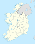
Hollymount (irl.: Maolla) – wieś w hrabstwie Mayo w Irlandii położona przy drodze R331, pomiędzy miastami Ballinrobe and Claremorris.
Przypisy
- ↑ Census 2011 Preliminary Report. [zarchiwizowane z tego adresu].
Media użyte na tej stronie
(c) Paul Anderson, CC BY-SA 2.0
Hollymount Primary School Hollymount primary school is located at the top of a hill accessed via a long lane (Hollymount Lane).Hollymount school is an extremely large, impressive building with a strong catholic heritage, the school's former headmistress (Sister James) was one of several nuns teaching at the school right up until the early 1990's.Adjacent to Hollymount school used to be a convent with splendid gardens and a grotto of Lady Mary, children would form a procession of prayer here on May day each year.
Sadly, however, the convent closed in the late 80's and much of the convent has now been knocked down and replaced with modern houses.
School pupils flourish at Hollymount http://archive.thisislancashire.co.uk/2007/1/18/962426.html


