Holyhead
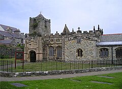
 Kościół St. Cybi w Holyhead | |
| Państwo | |
|---|---|
| Księstwo | |
| Hrabstwo | |
| Populacja (2001) • liczba ludności |
|
| Kod pocztowy | LL65 |
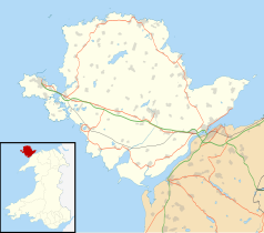
Położenie na mapie Anglesey Contains Ordnance Survey data © Crown copyright and database right, CC BY-SA 3.0 | |
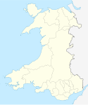
Położenie na mapie Wielkiej Brytanii (c) Karte: NordNordWest, Lizenz: Creative Commons by-sa-3.0 de | |
| Strona internetowa | |
| Portal | |
Holyhead (wal. Caergybi) – największe miasto w hrabstwie Anglesey, usytuowane w północno-zachodniej Walii na wyspie Holy Island. Liczba mieszkańców według spisu powszechnego z 2011 roku wynosiła 11 431 osób[1].
Przypisy
- ↑ Holyhead Built-up area - Local Area Report, Nomis - Official Labour Market Statistics [dostęp 2022-03-09].
Media użyte na tej stronie
(c) Karte: NordNordWest, Lizenz: Creative Commons by-sa-3.0 de
Location map of the United Kingdom
Autor: NordNordWest, Licencja: CC BY-SA 3.0
Location map of Wales, United Kingdom
Contains Ordnance Survey data © Crown copyright and database right, CC BY-SA 3.0
Blank map of the Anglesey, UK with the following information shown:
- Administrative borders
- Coastline, lakes and rivers
- Roads and railways
- Urban areas
Equirectangular map projection on WGS 84 datum, with N/S stretched 165%
Geographic limits:
- West: 4.75W
- East: 4.00W
- North: 53.45N
- South: 53.05N


