Honicknowle
| ||
(c) Mick Lobb, CC BY-SA 2.0 | ||
| Państwo | ||
| Kraj | ||
| Region | South West England | |
| Hrabstwo ceremonialne | Devon | |
| Unitary authority | Plymouth | |
| Populacja (2011) • liczba ludności | 13 939 | |
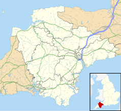
Położenie na mapie Devonu Contains Ordnance Survey data © Crown copyright and database right, CC BY-SA 3.0 | ||
Położenie na mapie Wielkiej Brytanii (c) Karte: NordNordWest, Lizenz: Creative Commons by-sa-3.0 de | ||
| 50,4108°N 4,1672°W/50,410800 -4,167220 | ||
| Portal | ||
Honicknowle – dzielnica miasta Plymouth, w Anglii, w Devon, w dystrykcie (unitary authority) Plymouth[1]. W 2011 miejscowość liczyła 13 939 mieszkańców[2]. Honicknowle jest wspomniana w Domesday Book (1086) jako Hanechelole/Hanenchelola[3].
Przypisy
- ↑ Ordnance Survey linked data
- ↑ Neighbourhood Statistics. [dostęp 2015-11-13]. [zarchiwizowane z tego adresu (2015-11-17)].
- ↑ The Domesday Book online
Media użyte na tej stronie
Contains Ordnance Survey data © Crown copyright and database right, CC BY-SA 3.0
Map of Devon, UK with the following information shown:
- Administrative borders
- Coastline, lakes and rivers
- Motorways and primary routes
- Urban areas
Equirectangular map projection on WGS 84 datum, with N/S stretched 150%
Geographic limits:
- West: 4.72W
- East: 2.86W
- North: 51.3N
- South: 50.16N
(c) Karte: NordNordWest, Lizenz: Creative Commons by-sa-3.0 de
Location map of the United Kingdom
Flag of England. Saint George's cross (a red cross on a white background), used as the Flag of England, the Italian city of Genoa and various other places.
(c) Mick Lobb, CC BY-SA 2.0
Tower block, Honicknowle, Plymouth Am estate of 'prefabs' was established here immediately after the second world war. These were then replaced with prefabricated houses and blocks of flats as they became ready for replacement.


