Honiton
(c) Richard Rogerson, CC BY-SA 2.0 | |
| Państwo | |
|---|---|
| Kraj | |
| Hrabstwo | |
| Populacja (2002) • liczba ludności |
|
| Nr kierunkowy | 0144 |
| Kod pocztowy | EX14 |
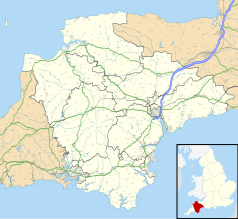
Położenie na mapie Devonu Contains Ordnance Survey data © Crown copyright and database right, CC BY-SA 3.0 | |
Położenie na mapie Wielkiej Brytanii (c) Karte: NordNordWest, Lizenz: Creative Commons by-sa-3.0 de | |
| Strona internetowa | |
| Portal | |
Honiton (IPA /hʌnɪtɘn/ lub /hɒnitɘn/) - miasto w Wielkiej Brytanii, w Anglii w hrabstwie Devon, położone nad rzeką Otter, 24 km na północny wschód od Exeter. Stacja kolejowa na linii Londyn-Exeter.
Historia
Miasto położone na rzymskim szlaku Fosse Way z Exeter do Lincoln. Wzmiankowane w Domesday Book jako Honetone. W czasach nowożytnych w mieście rozwinął się przemysł - tu właśnie wyprodukowano pierwszą w Anglii koronkę, której sposób wykonania przywieźli emigranci flamandzcy. Królowa Wiktoria miała suknię ślubną ozdobioną koronkami z Honiton[1]. W XVIII w. miasto strawił pożar. Ponowny rozwój nastąpił w XX w., po wybudowaniu linii kolejowej.
Miasta partnerskie
Przypisy
- ↑ Honiton Lace. [dostęp 2008-06-01]. [zarchiwizowane z tego adresu (2008-06-11)].
Media użyte na tej stronie
(c) Karte: NordNordWest, Lizenz: Creative Commons by-sa-3.0 de
Location map of the United Kingdom
Flag of England. Saint George's cross (a red cross on a white background), used as the Flag of England, the Italian city of Genoa and various other places.
(c) Richard Rogerson, CC BY-SA 2.0
St. Pauls Church, Honiton, Devon St. Paul's Church was built in 1835 and was consecrated by Bishop Henry Philpotts, Bishop of Exeter, in 1838. It is built of local chert and Beer stone and was designed by Charles Fowler of London in the Norman style. Owing to the orientation of the site on which it stands, the Church actually lies North-South. It is 132 feet in length and 58 feet in breadth. The tower, which is a conspicuous landmark in the Otter valley, is 104 feet high and accommodates a clock made by Matthew Murch of Honiton in 1851. http://www.honitoncofe.org/history.htm
Contains Ordnance Survey data © Crown copyright and database right, CC BY-SA 3.0
Map of Devon, UK with the following information shown:
- Administrative borders
- Coastline, lakes and rivers
- Motorways and primary routes
- Urban areas
Equirectangular map projection on WGS 84 datum, with N/S stretched 150%
Geographic limits:
- West: 4.72W
- East: 2.86W
- North: 51.3N
- South: 50.16N


