Horgenzell
| gmina | |||
 | |||
| |||
| Państwo | |||
|---|---|---|---|
| Kraj związkowy | |||
| Rejencja | Tybinga | ||
| Powiat | Ravensburg | ||
| Związek regionalny | Bodensee-Oberschwaben | ||
| Wspólnota | Wspólnota administracyjna Wilhelmsdorf | ||
| Powierzchnia | 56,16 km² | ||
| Wysokość | 620 m n.p.m. | ||
| Populacja (31 grudnia 2010) • liczba ludności | 4 855 | ||
| • gęstość | 86 os./km² | ||
| Numer kierunkowy | 07504 | ||
| Kod pocztowy | 88263 | ||
| Tablice rejestracyjne | RV | ||
Adres urzędu: Kornstraße 4488287 Horgenzell | |||
Położenie na mapie powiatu | |||
| 47°48′N 9°30′E/47,800000 9,500000 | |||
| Strona internetowa | |||
| Portal | |||
Horgenzell – miejscowość i gmina w Niemczech, w kraju związkowym Badenia-Wirtembergia, w rejencji Tybinga, w regionie Bodensee-Oberschwaben, w powiecie Ravensburg, wchodzi w skład wspólnoty administracyjnej Wilhelmsdorf.
Geografia
Gmina leży pomiędzy Jeziorem Bodeńskim a górami Górnej Szwabii, ok. 10 km od Ravensburga i Weingarten oraz około 20 km od Friedrichshafen.
Historia
Po raz pierwszy o tych ziemiach usłyszano w 1094 pod nazwą Horguncella, lecz pochodzenie tej nazwy jest do dziś niejasne.
Gmina powstała w 1972 z połączenia gmin Hasenweiler, Kappel, Wolketsweiler oraz Zogenweiler.
Zabytki
- kościół św. Jana Baptysty (St. Johannes Baptist w Danketsweiler
- kościół Maryi Bożej Rodzicielki (Maria Geburt) w Hasenweiler
- kościół św. Urszuli (St. Ursula) w Horgenzell
- kościół św. Gawła (St. Gallus) w Kappel
- kościół św. Wenancjusza (St. Venantius) w Pfärrenbach
- kościół św. Stefana (St. Stephanus) w Ringgenweiler
- kościół św. Jana Baptysty (St. Jojannes Baptist) w Wilhelmskirch
- kościół św. Felixa i Reguli (St. Felix und Regula) w Zogenweiler
Galeria

Kościół Maryi Bożej Rodzicielki (Maria Geburt) w Hasenweiler

Kościół św. Urszuli (St. Ursula) w Horgenzell
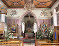
Wnętrze kościoła św. Wenancjusza (St. Venantius) w Pfärrenbach
- Siedziba powiatu: Ravensburg
| Miasta | |
|---|---|
| Gminy | |
| Wspólnoty administracyjne | |
| Związki gmin |

Media użyte na tej stronie


Autor: Photo: Andreas Praefcke, Licencja: CC BY 3.0
Pfarrkirche Mariä Geburt, Hasenweiler, Gemeinde Horgenzell
Außenbau
|
|
|
|
|
|
|
|

Autor: Photo: Andreas Praefcke, Licencja: CC BY 3.0
Filialkirche St. Venantius, Pfärrenbach, Gemeinde Horgenzell
Blick vom Eingang in das Kirchenschiff und zum Chor

This coat of arms was drawn based on its blazon which – being a written description – is free from copyright. Any illustration conforming with the blazon of the arms is considered to be heraldically correct. Thus several different artistic interpretations of the same coat of arms can exist. The design officially used by the armiger is likely protected by copyright, in which case it cannot be used here.
Individual representations of a coat of arms, drawn from a blazon, may have a copyright belonging to the artist, but are not necessarily derivative works.

Autor: Andreas Praefcke, Licencja: CC BY 3.0
Horgenzell: Pfarrkirche St. Ursula, Horgenzell (während der Renovierung 2005)