Hornisgrinde
| Ten artykuł od 2022-07 wymaga zweryfikowania podanych informacji. |
 Hornisgrinde | |
| Państwo | |
|---|---|
| Położenie | |
| Pasmo | |
| Wysokość | 1164 m n.p.m. |
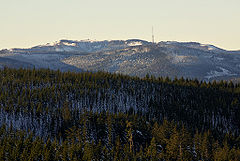
Hornisgrinde – najwyższa góra północnego Schwarzwaldu (Niemcy), o wysokości 1164 m n.p.m.
Media użyte na tej stronie
Baden-Wuerttemberg location map G.svg
Autor: Hanhil based on previous work by Ssch and kjunix, Licencja: CC BY-SA 3.0
Location map of Baden-Württemberg, showing position of Baden-Württemberg within Germany
Autor: Hanhil based on previous work by Ssch and kjunix, Licencja: CC BY-SA 3.0
Location map of Baden-Württemberg, showing position of Baden-Württemberg within Germany
U+25B2.svg
Black up-pointing triangle ▲, U+25B2 from Unicode-Block Geometric Shapes (25A0–25FF)
Black up-pointing triangle ▲, U+25B2 from Unicode-Block Geometric Shapes (25A0–25FF)
Hornisgrinde-from-Hohloh-IMGP0125.jpg
Autor: Rainer Lück http://1RL.de, Licencja: CC BY-SA 3.0
Northern Black Forest: Hornisgrinde seen from Hohloh.
Autor: Rainer Lück http://1RL.de, Licencja: CC BY-SA 3.0
Northern Black Forest: Hornisgrinde seen from Hohloh.
Relief Map of Germany.png
Autor: derivative work Виктор_В, Licencja: CC BY-SA 3.0
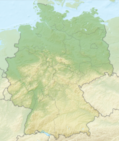
Relief map of Germany
Autor: derivative work Виктор_В, Licencja: CC BY-SA 3.0
Relief map of Germany


