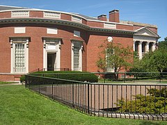
Houghton Library
 | |
| Państwo | |
|---|---|
| Data założenia | |
| 42°22′23,5″N 71°06′57,4″W/42,373194 -71,115944 | |
| Strona internetowa | |
Houghton Library – jedna z ponad siedemdziesięciu bibliotek należących do bibliotecznego systemu Harvard University. Mieści się w południowej części Harvard Yard, w pobliżu Widemer Library.
Historia
W bibliotece przechowywanych jest ponad 16 milionów woluminów. Ulokowany tu został najcenniejszy zbiór rękopisów oraz starodruków z będących w posiadaniu Harvard University[1]. Budynek biblioteki zaczęto budować w 1938 roku, a bibliotekę otwarto w 1942 roku[2].
Znajduje się tu zbiór średniowiecznych oraz renesansowych rękopisów oraz ponad 2500 starodruków (inkunabuły), ponadto kolekcja cennych dokumentów (Samuel Johnson, Emily Dickinson, Henry Wadsworth Longfellow, Margaret Fuller, Theodore Roosevelt, itd).
Kolekcja papirusów zapoczątkowana została przez donację pochodzącą od Egypt Exploration Fund z lat 1901–1909, za finansowanie prac archeologicznych w Egipcie[2]. Rękopisy pochodzą z okresu od 3000 p.n.e. do 1600 roku. Większość rękopisów pisana jest językami kultury Zachodu. Znaczna część rękopisów reprezentuje Orient i pisana jest w języku arabskim, językach Indii, języku perskim i syryjskim[2].
W bibliotece przechowywane są zarówno wczesne rękopisy greckiego Nowego Testamentu: , [3], jak i późne lekcjonarze Nowego Testamentu: ℓ 296, ℓ 297, ℓ 298.
Przypisy
- ↑ About Harvard Library, Harvard Library [dostęp 2021-01-14] (ang.).
- ↑ a b c Early Books & Manuscripts - Collections - Houghton Library - Harvard College Library, web.archive.org, 6 czerwca 2018 [dostęp 2021-01-14] [zarchiwizowane z adresu 2018-06-06].
- ↑ K. Aland, B. Aland: The Text of the New Testament: An Introduction to the Critical Editions and to the Theory and Practice of Modern Textual Criticism. przeł. Erroll F. Rhodes. Michigan: William B. Eerdmans Publishing Company, 1995, s. 96. ISBN 978-0-8028-4098-1.
Linki zewnętrzne
Media użyte na tej stronie
Autor: Uwe Dedering, Licencja: CC BY-SA 3.0
Location map of the USA (without Hawaii and Alaska).
EquiDistantConicProjection:
Central parallel:
* N: 37.0° N
Central meridian:
* E: 96.0° W
Standard parallels:
* 1: 32.0° N
* 2: 42.0° N
Made with Natural Earth. Free vector and raster map data @ naturalearthdata.com.
Formulas for x and y:
x = 50.0 + 124.03149777329222 * ((1.9694462586094064-({{{2}}}* pi / 180))
      * sin(0.6010514667026994 * ({{{3}}} + 96) * pi / 180))
y = 50.0 + 1.6155950752393982 * 124.03149777329222 * 0.02613325650382181
      - 1.6155950752393982  * 124.03149777329222 *
     (1.3236744353715044  - (1.9694462586094064-({{{2}}}* pi / 180))
      * cos(0.6010514667026994 * ({{{3}}} + 96) * pi / 180))
The flag of Navassa Island is simply the United States flag. It does not have a "local" flag or "unofficial" flag; it is an uninhabited island. The version with a profile view was based on Flags of the World and as a fictional design has no status warranting a place on any Wiki. It was made up by a random person with no connection to the island, it has never flown on the island, and it has never received any sort of recognition or validation by any authority. The person quoted on that page has no authority to bestow a flag, "unofficial" or otherwise, on the island.
Autor: Alexrk2, Licencja: CC BY 3.0
Location map of Massachusetts, USA
Houghton Library, Harvard University, Cambridge, Massachusetts, USA.


