Houlton (Maine)
 Plac targowy w Houlton, 1911 r. | |
| Państwo | |
|---|---|
| Stan | |
| Hrabstwo | |
| Data założenia | 1831 |
| Populacja (2010) • liczba ludności |
|
| Nr kierunkowy | 207 |
| Kod pocztowy | 04730, 04761 |
| Strona internetowa | |
| Portal | |
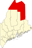
Houlton – miasto (town), ośrodek administracyjny hrabstwa Aroostook, we wschodniej części stanu Maine, w Stanach Zjednoczonych, położone nad rzeką Meduxnekeag, przy granicy kanadyjskiej[1]. W 2010 roku miasto liczyło 6123 mieszkańców[2].
Pierwsi osadnicy przybyli tu w 1805 roku. Jednym z nich był Joseph Houlton, którego imieniem nazwano osadę. Formalne założenie miejscowości, która rozwinęła się jako ośrodek produkcji drewna, nastąpiło w 1831 roku. W latach 1828-1847 znajdował się tutaj garnizon armii amerykańskiej, który brał udział w bezkrwawej wojnie o Aroostook[1].
Lokalna gospodarka w dużej mierze opiera się na rolnictwie (uprawa ziemniaków, hodowla bydła) oraz przemyśle drzewnym[1].
W mieście znajduje się północny skraj autostraty międzystanowej nr 95.
Przypisy
- ↑ a b c Houlton, [w:] Encyclopædia Britannica [online] [dostęp 2014-09-14] (ang.).
- ↑ Houlton town, Maine. American FactFinder – US Census Bureau. [dostęp 2014-09-14]. [zarchiwizowane z tego adresu (2015-01-18)]. (ang.).
Media użyte na tej stronie
Autor: Uwe Dedering, Licencja: CC BY-SA 3.0
Location map of the USA (without Hawaii and Alaska).
EquiDistantConicProjection:
Central parallel:
* N: 37.0° N
Central meridian:
* E: 96.0° W
Standard parallels:
* 1: 32.0° N
* 2: 42.0° N
Made with Natural Earth. Free vector and raster map data @ naturalearthdata.com.
Formulas for x and y:
x = 50.0 + 124.03149777329222 * ((1.9694462586094064-({{{2}}}* pi / 180))
      * sin(0.6010514667026994 * ({{{3}}} + 96) * pi / 180))
y = 50.0 + 1.6155950752393982 * 124.03149777329222 * 0.02613325650382181
      - 1.6155950752393982  * 124.03149777329222 *
     (1.3236744353715044  - (1.9694462586094064-({{{2}}}* pi / 180))
      * cos(0.6010514667026994 * ({{{3}}} + 96) * pi / 180))
The flag of Navassa Island is simply the United States flag. It does not have a "local" flag or "unofficial" flag; it is an uninhabited island. The version with a profile view was based on Flags of the World and as a fictional design has no status warranting a place on any Wiki. It was made up by a random person with no connection to the island, it has never flown on the island, and it has never received any sort of recognition or validation by any authority. The person quoted on that page has no authority to bestow a flag, "unofficial" or otherwise, on the island.
Autor: Alexrk2, Licencja: CC BY 3.0
Ta mapa została stworzona za pomocą GeoTools.
North Side Market Square, Houlton, Maine
This is a locator map showing Aroostook County in Maine. For more information, see Commons:United States county locator maps.


