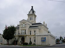
Hrabstwo Adair (Kentucky)
| hrabstwo | |
| Państwo | |
|---|---|
| Stan | |
| Siedziba | Columbia |
| Kod statystyczny | FIPS 6-4: 54001 |
| Powierzchnia | 1067,67 km²[1] |
| Populacja (2010) • liczba ludności |
|
Położenie na mapie Kentucky | |
| 37°06′36″N 85°16′48″W/37,110000 -85,280000 | |
| Strona internetowa | |
| Portal | |
Hrabstwo Adair (ang. Adair County) – hrabstwo w stanie Kentucky w Stanach Zjednoczonych. Obszar całkowity hrabstwa obejmuje powierzchnię 412,23 mil² (1067,67 km²). Według spisu United States Census Bureau w roku 2010 miało 18 656 mieszkańców[2].
Hrabstwo powstało w 1802 roku[3].
Na jego terenie znajduje się miejscowość Columbia[4].
Hrabstwo należy do nielicznych hrabstw w Stanach Zjednoczonych należących do tzw. dry county, czyli hrabstw gdzie decyzją lokalnych władz obowiązuje całkowita prohibicja[5][6].
| Populacja hrabstwa w poprzednich latach[3] | |
|---|---|
| Rok | Liczba ludności |
| 1980 | 15 123 |
| 1990 | 15 360 |
| 2000 | 17 244 |
| 2010 | 18 656 |
Demografia
W 2019 roku do największych grup należą osoby pochodzenia: angielskiego (19,6%), „amerykańskiego” (15,7%), niemieckiego (8,3%), irlandzkiego (8,3%), afroamerykańskiego (3,1%) i szkockiego lub szkocko–irlandzkiego (3,1%)[7].
Religia
Do grup religijnych z największym członkostwem, w 2010 roku należą[8]:
- protestanci ewangelikalni – 24%[9]:
- Południowa Konwencja Baptystów – 8%,
- Kościoły Chrystusowe – 7,6%,
- zielonoświątkowcy – 2,5%,
- bezdenominacyjni – 2,4%,
- uświęceniowcy – 2,4%,
- amisze – 0,56%,
- adwentyści dnia siódmego – 0,53%,
- protestanci głównego nurtu – 10,8%:
- Zjednoczony Kościół Metodystyczny – 10,5%,
- katolicy – 0,75%.
Obecna jest także ewangelikalna i anabaptystyczna denominacja Braci w Kościele Chrystusowym, która nie udostępniła swoich danych statystycznych, a która posiada 4 zbory[8].
Przypisy
- ↑ US Census Bureau: Population, Housing Units, Area, and Density: 2000 (ang.). [dostęp 2012-05-22]. [zarchiwizowane z tego adresu (2016-03-09)].
- ↑ a b US Census Bureau: Adair County (ang.). Quickfacts. [dostęp 2012-05-22].
- ↑ a b National Association of Counties: Adair County, KY (ang.). [dostęp 2012-05-22].
- ↑ National Association of Counties: Places in Adair County, KY (ang.). [dostęp 2012-05-22].
- ↑ Wet and Dry Counties (ang.). National Alcoholic Beverage Control Association. [dostęp 2018-02-16].
- ↑ Dry Counties Of The United States (ang.). WorldAtlas. [dostęp 2018-02-16].
- ↑ 2019: ACS 5-Year Estimates Data Profiles (DP05/DP02), data.census.gov [dostęp 2021-08-08].
- ↑ a b Adair County (Kentucky) - Religious Traditions, 2010, www.thearda.com [dostęp 2021-08-08].
- ↑ Evangelical Protestant Counties (2010) | QuickLists | The Association of Religion Data Archives, www.thearda.com [dostęp 2021-08-08].
Media użyte na tej stronie
The flag of Navassa Island is simply the United States flag. It does not have a "local" flag or "unofficial" flag; it is an uninhabited island. The version with a profile view was based on Flags of the World and as a fictional design has no status warranting a place on any Wiki. It was made up by a random person with no connection to the island, it has never flown on the island, and it has never received any sort of recognition or validation by any authority. The person quoted on that page has no authority to bestow a flag, "unofficial" or otherwise, on the island.
Front and southeastern side of the Columbia Church of the Nazarene, located on Jamestown Street in Columbia, Kentucky, United States.
This is a locator map showing Adair County in Kentucky. For more information, see Commons:United States county locator maps.


