Hrabstwo Aitkin
| hrabstwo | |
(c) I, Elkman, CC-BY-SA-3.0 | |
| Państwo | |
|---|---|
| Stan | |
| Siedziba | Aitkin |
| Kod statystyczny | FIPS 6-4: 27001 |
| Powierzchnia | 5168 km² |
| Populacja (2005) • liczba ludności | 16 174 |
| • gęstość | 3 os./km² |
| Strefa czasowa | Central: UTC-6/-5 |
Położenie na mapie Minnesota | |
| Strona internetowa | |
| Portal | |
Hrabstwo Aitkin ze stolicą w mieście Aitkin, znajduje się we wschodniej części stanu Minnesota, USA. W roku 2005 zamieszkiwało je 16 174 osób, z czego zdecydowaną większość stanowili biali (96.41%). Swoją nazwę hrabstwo zawdzięcza postaci Williama Aitkina, handlarza futer pracującego dla „The American Fur Company”.
Historia
Hrabstwo Aitkin zostało ustanowione w roku 1857 pod nazwą "Hrabstwo Aiken", która została zmieniona na obecną w roku 1872. Początkowo Aitkin składało się z 17 miasteczek zlokalizowanych w okolicach jeziora Mille Lacs. W roku 1871 zostało zreorganizowane, przejmując część ziem od hrabstw Cass i Itasca, tracąc natomiast kawałek na południowym zachodzie na rzecz hrabstwa Crow Wing.
Warunki naturalne
Hrabstwo Aitkin liczy 5168 km² (1995 mi²). W tym na lądzie 4712 km² (1819 mi²) oraz 456 km² (176 mi²) wód. Na jego terenie znajduje się rezerwat Indian Mille Lacs. Graniczy z 8 innymi hrabstwami:
- Hrabstwo Itasca (północ)
- Hrabstwo St.Louis (północny wschód)
- Hrabstwo Carlton (wschód)
- Hrabstwo Pine (południowy wschód)
- Hrabstwo Kanabec (południe)
- Hrabstwo Mille Lacs (południe)
- Hrabstwo Crow Wing (południowy zachód)
- Hrabstwo Cass (północny zachód)
Główne szlaki drogowe
|
|
Miasta
Media użyte na tej stronie
The flag of Navassa Island is simply the United States flag. It does not have a "local" flag or "unofficial" flag; it is an uninhabited island. The version with a profile view was based on Flags of the World and as a fictional design has no status warranting a place on any Wiki. It was made up by a random person with no connection to the island, it has never flown on the island, and it has never received any sort of recognition or validation by any authority. The person quoted on that page has no authority to bestow a flag, "unofficial" or otherwise, on the island.
Minnesota State Highway route marker
Autor:
- real name: Artur Jan Fijałkowski
- pl.wiki: WarX
- commons: WarX
- mail: [1]
- jabber: WarX@jabber.org
- irc: [2]
- software: own perl scripts
Piramida wieku dla hrabstwa Aitkin w stanie Minnesota w USA na podstawie spisu ludności z 2000 roku
Minnesota State Highway route marker
Minnesota State Highway route marker
750 mm × 600 mm (30 in × 24 in) U.S. Highway shield, made to the specifications of the 2004 edition of Standard Highway Signs. (Note that there is a missing "J" label on the left side of the diagram.) Uses the Roadgeek 2005 fonts. (United States law does not permit the copyrighting of typeface designs, and the fonts are meant to be copies of a U.S. Government-produced work anyway.)
Minnesota State Highway route marker
Minnesota State Highway route marker
Minnesota State Highway route marker
Minnesota State Highway route marker
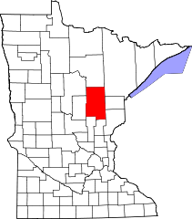
This is a locator map showing Aitkin County in Minnesota. For more information, see Commons:United States county locator maps.


