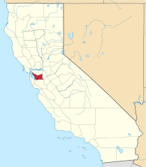
Hrabstwo Alameda
| hrabstwo | |||
 | |||
| |||
| Państwo | |||
|---|---|---|---|
| Stan | |||
| Siedziba | |||
| Kod statystyczny | FIPS 6-4: 06001 | ||
| Powierzchnia | 2126,77 km²[1] | ||
| Populacja (2010) • liczba ludności |
| ||
| • gęstość | 710 os./km² | ||
Położenie na mapie Kalifornia | |||
| 37°39′00″N 121°54′36″W/37,650000 -121,910000 | |||
| Strona internetowa | |||
| Portal | |||
Hrabstwo Alameda (ang. Alameda County) – hrabstwo w stanie Kalifornia, w Stanach Zjednoczonych. Obszar całkowity hrabstwa obejmuje powierzchnię 821,15 mil² (2126,77 km²). Według przeprowadzonego w roku 2010 przez United States Census Bureau spisu powszechnego miało 1 510 271 mieszkańców[2].
Hrabstwo powstało w 1853 roku[3].
Miejscowości
- Alameda
- Albany
- Berkeley
- Dublin
- Emeryville
- Fremont
- Hayward
- Livermore
- Newark
- Oakland
- Piedmont
- Pleasanton
- San Leandro
- Union City[4]
CDP
- Ashland
- Castro Valley
- Cherryland
- Fairview
- San Lorenzo
- Sunol
Przypisy
- ↑ US Census Bureau: Population, Housing Units, Area, and Density: 2000 (ang.). [dostęp 2012-08-31]. [zarchiwizowane z tego adresu (2015-07-08)].
- ↑ a b US Census Bureau: Alameda County (ang.). Quickfacts. [dostęp 2011-11-05].
- ↑ National Association of Counties: Alameda County, CA (ang.). [dostęp 2010-12-26].
- ↑ National Association of Counties: Places in Alameda County, CA (ang.). [dostęp 2010-12-26].
Media użyte na tej stronie
The flag of Navassa Island is simply the United States flag. It does not have a "local" flag or "unofficial" flag; it is an uninhabited island. The version with a profile view was based on Flags of the World and as a fictional design has no status warranting a place on any Wiki. It was made up by a random person with no connection to the island, it has never flown on the island, and it has never received any sort of recognition or validation by any authority. The person quoted on that page has no authority to bestow a flag, "unofficial" or otherwise, on the island.
Flag of Alameda County, California, USA
Autor:
- real name: Artur Jan Fijałkowski
- pl.wiki: WarX
- commons: WarX
- mail: [1]
- jabber: WarX@jabber.org
- irc: [2]
- software: own perl scripts
Piramida wieku dla hrabstwa Alameda w stanie Kalifornia w USA na podstawie spisu ludności z 2000 roku
This is a locator map showing Alameda County in California. For more information, see Commons:United States county locator maps.
Autor: Konky2000, Licencja: CC BY-SA 2.5
Composite of two images taken by Aran Johnson on September 8, 2005 at 18:42 PM local time. Looking west across Lake Merritt. The street visible through the trees in the foreground is Grand Avenue. On the other side of the lake, the road running alongside the curve of the lake is Lakeshore Drive. The low lying building at the far end of the lake just to the right of center, is the Henry J. Kaiser Convention Center. To the right of that, the square building with the peaked roof is the Oakland Court House. The brick building at the far right of the image is the Bellevue-Staten Building a residential high rise dating from the 1920's.
Flag of California. This version is designed to accurately depict the standard print of the bear as well as adhere to the official flag code regarding the size, position and proportion of the bear, the colors of the flag, and the position and size of the star.


