Hrabstwo Ashtabula
| ||||
| ||||
 | ||||
| Państwo | ||||
| Stan | ||||
| Siedziba | Jefferson | |||
| Powierzchnia | 3544 km² | |||
| Populacja (2000) • liczba ludności | 102 728 | |||
| • gęstość | 56 os./km² | |||
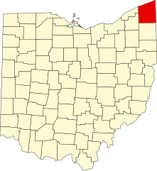
Położenie na mapie Ohio | ||||
| Strona internetowa | ||||
| Portal | ||||
Hrabstwo Ashtabula (ang. Ashtabula County) – hrabstwo w Stanach Zjednoczonych, w stanie Ohio. Według danych z 2000 roku hrabstwo miało 102 728 mieszkańców.
Geografia
Ashtabula jest największym hrabstwem w stanie Ohio pod względem powierzchni. Według United States Census Bureau hrabstwo zajmuje powierzchnię 3544 km², z czego 1819 km² zajmuje ląd, a 1725 km² woda (48,67%).
Miasta
CDP
- Austinburg
- Edgewood
Wioski
- Andover
- Geneva-on-the-Lake
- Jefferson
- North Kingsville
- Orwell
- Roaming Shores
- Rock Creek
Sąsiednie hrabstwa
- Hrabstwo Erie (północny wschód)
- Hrabstwo Crawford (wschód)
- Hrabstwo Trumbull (południe)
- Hrabstwo Geauga (południowy zachód)
- Hrabstwo Lake (północny zachód)
Linki zewnętrzne
Media użyte na tej stronie
The flag of Navassa Island is simply the United States flag. It does not have a "local" flag or "unofficial" flag; it is an uninhabited island. The version with a profile view was based on Flags of the World and as a fictional design has no status warranting a place on any Wiki. It was made up by a random person with no connection to the island, it has never flown on the island, and it has never received any sort of recognition or validation by any authority. The person quoted on that page has no authority to bestow a flag, "unofficial" or otherwise, on the island.
This is a locator map showing Ashtabula County in Ohio. For more information, see Commons:United States county locator maps.
Front and eastern side of the new section of the Ashtabula County Courthouse, located at 25 W. Jefferson Street in Jefferson, Ohio, United States.
Seal of Ashtabula County Ohio


