Hrabstwo Cameron (Teksas)
| hrabstwo | |||
| |||
| Państwo | |||
|---|---|---|---|
| Stan | |||
| Siedziba | Brownsville | ||
| Data powstania | 1848[1] | ||
| Powierzchnia | 3305 km² | ||
| Populacja (2010) • liczba ludności | 406 220[2] | ||
| • gęstość | 101,4 os./km² | ||
| Strefa czasowa | UTC-6:00 UTC-5:00 | ||
Położenie na mapie Teksas | |||
| 26°09′00″N 97°27′00″W/26,150000 -97,450000 | |||
| Strona internetowa | |||
| Portal | |||
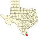
Hrabstwo Cameron – hrabstwo położone w USA, najbardziej na południe wysuniętej części stanu Teksas, nad Zatoką Meksykańską. Hrabstwo utworzono w 1848 r. poprzez wydzielenie terytorium z hrabstwa Nueces[1]. Siedzibą władz hrabstwa jest miasto Brownsville, w którym mieszka około 44% mieszkańców hrabstwa[2].
Nazwę hrabstwu nadano na cześć Ewena Camerona mierniczego Republiki Teksasu, uczestnika ekspedycji dokonującej pomiarów na terenie obecnego hrabstwa Cameron[3][4].
Hrabstwo jest jednym z największych producentów cytrusów w Teksasie. Produkcja głównie jest skoncentrowana w dolinie rzeki Rio Grande[5].
Na terenie hrabstwa znajduje się Park Stanowy Resaca de la Palma[6].
Miasta
| Miasta | CDP | Wsie | ||
|---|---|---|---|---|
|
|
|
| |
Sąsiednie hrabstwa
- Hrabstwo Willacy (północ)
- Hrabstwo Hidalgo (zachód)
- Matamoros, Tamaulipas, Meksyk (południe)
Główne drogi
Przez hrabstwo przechodzą trzy autostrady i dwie drogi krajowe:
 I-2
I-2 I-69
I-69 I-169
I-169
 U.S. Route 83
 U.S. Route 281
Przypisy
- ↑ a b Texas: Individual County Chronologies (ang.). [dostęp 2018-01-09]. [zarchiwizowane z tego adresu (2015-05-13)].
- ↑ a b Population of Caldwell County, Texas Population Census 2010 and 2000 (ang.). CensusViewer. [dostęp 2018-01-09].
- ↑ Thomas W. Cutrer: Cameron, Ewen (ang.). Handbook of Texas Online, Texas State Historical Association. [dostęp 2018-01-10].
- ↑ Alicia A. Garza and Christopher Long: Cameron County (ang.). Handbook of Texas Online, Texas State Historical Association. [dostęp 2018-01-10].
- ↑ W. H. Friend: Citrus fruit culture (ang.). Handbook of Texas Online, Texas State Historical Association. [dostęp 2018-01-09].
- ↑ Resaca de la Palma State Park (ang.). Texas Parks and Wildlife Department. [dostęp 2018-01-10].
Media użyte na tej stronie
The flag of Navassa Island is simply the United States flag. It does not have a "local" flag or "unofficial" flag; it is an uninhabited island. The version with a profile view was based on Flags of the World and as a fictional design has no status warranting a place on any Wiki. It was made up by a random person with no connection to the island, it has never flown on the island, and it has never received any sort of recognition or validation by any authority. The person quoted on that page has no authority to bestow a flag, "unofficial" or otherwise, on the island.
600 mm by 600 mm (24 in by 24 in) Interstate shield, made to the specifications of the 2004 edition of Standard Highway Signs (sign M1-1). Uses the Roadgeek 2005 fonts. (United States law does not permit the copyrighting of typeface designs, and the fonts are meant to be copies of a U.S. Government-produced work anyway.) Colors are from [1] (Pantone Red 187 and Blue 294), converted to RGB by [2]. The outside border has a width of 1 (1 mm) and a color of black so it shows up; in reality, signs have no outside border.
(c) Jaedza z angielskojęzycznej Wikipedii, CC-BY-SA-3.0
This is a picture of the current Cameron County Courthouse on 964 E. Harrison St in Brownsville, Texas, United States.
600 mm × 600 mm (24 in × 24 in) U.S. Highway shield, made to the specifications of the 2004 edition of Standard Highway Signs. (Note that there is a missing "J" label on the left side of the diagram.) Uses the Roadgeek 2005 fonts. (United States law does not permit the copyrighting of typeface designs, and the fonts are meant to be copies of a U.S. Government-produced work anyway.)
750 mm × 600 mm (30 in × 24 in) U.S. Highway shield, made to the specifications of the 2004 edition of Standard Highway Signs. (Note that there is a missing "J" label on the left side of the diagram.) Uses the Roadgeek 2005 fonts. (United States law does not permit the copyrighting of typeface designs, and the fonts are meant to be copies of a U.S. Government-produced work anyway.)
Logo of Cameron County, Texas
750 mm by 600 mm (30 in by 24 in) Interstate shield, made to the specifications of the 2004 edition of Standard Highway Signs (sign M1-1). Uses the Roadgeek 2005 fonts. (United States law does not permit the copyrighting of typeface designs, and the fonts are meant to be copies of a U.S. Government-produced work anyway.) Colors are from [1] (Pantone Red 187 and Blue 294), converted to RGB by [2]. The outside border has a width of 1 (1 mm) and a color of black so it shows up; in reality, signs have no outside border.
750 mm by 600 mm (30 in by 24 in) Interstate shield, made to the specifications of the 2004 edition of Standard Highway Signs (sign M1-1). Uses the Roadgeek 2005 fonts. (United States law does not permit the copyrighting of typeface designs, and the fonts are meant to be copies of a U.S. Government-produced work anyway.) Colors are from [1] (Pantone Red 187 and Blue 294), converted to RGB by [2]. The outside border has a width of 1 (1 mm) and a color of black so it shows up; in reality, signs have no outside border.
Autor:
- real name: Artur Jan Fijałkowski
- pl.wiki: WarX
- commons: WarX
- mail: [1]
- jabber: WarX@jabber.org
- irc: [2]
- software: own perl scripts
Piramida wieku dla hrabstwa Cameron w stanie Teksas w USA na podstawie spisu ludności z 2000 roku
This is a locator map showing Cameron County in Texas. For more information, see Commons:United States county locator maps.


