Hrabstwo Charles
| ||||
| ||||
 | ||||
| Państwo | ||||
|---|---|---|---|---|
| Stan | ||||
| Siedziba | La Plata | |||
| Kod statystyczny | FIPS 6-4: 24017 | |||
| Powierzchnia | 1 666 km² | |||
| Populacja (2000) • liczba ludności | 120 546 | |||
| • gęstość | 101 os./km² | |||
| Strefa czasowa | Eastern: UTC-5/-4 | |||
Położenie na mapie Maryland | ||||
| Strona internetowa | ||||
| Portal | ||||
Hrabstwo Charles (ang. Charles County) – hrabstwo w stanie Maryland w Stanach Zjednoczonych. Hrabstwo zajmuje powierzchnię całkowitą 1 666 km², z czego 1 194 km² stanowi powierzchnia lądowa.[1] Według szacunków US Census Bureau w roku 2006 hrabstwo Calvert liczyło 140 416 mieszkańców.[2] Siedzibą hrabstwa jest miejscowość La Plata.
Historia
Hrabstwo Charles zostało utworzone w 1658 roku. Nazwa pochodzi od imienia Charlesa Calverta, trzeciego barona Baltimore, właściciela kolonii Maryland.[3] W 1695 roku część hrabstwa Charles została połączona z częścią hrabstwa Calvert i zostało w ten sposób utworzone nowe hrabstwo Prince George’s.
Geografia
Całkowita powierzchnia hrabstwa wynosi 1 666 km², z czego 1 194 km² stanowi powierzchnia lądowa, a 472 km² (28,3%) powierzchnia wodna. Najwyższy punkt w hrabstwie ma wysokość 72 m n.p.m., zaś najniższy punkt położony jest na poziomie morza przy ujściu rzeki Potomak do zatoki Chesapeake.
Miasta
- Indian Head
- La Plata
- Port Tobacco Village
CDP
- Benedict
- Bennsville
- Bryans Road
- Bryantown
- Cobb Island
- Hughesville
- Potomac Heights
- Pomfret
- Rock Point
- Waldorf
Przypisy
- ↑ Podstawowe dane demograficzne dotyczące hrabstw w stanie Maryland US Census Bureau
- ↑ Maryland population estimates by county US Census Bureau
- ↑ Profil hrabstwa Charles Maryland State Archives (en)
Media użyte na tej stronie
The flag of Navassa Island is simply the United States flag. It does not have a "local" flag or "unofficial" flag; it is an uninhabited island. The version with a profile view was based on Flags of the World and as a fictional design has no status warranting a place on any Wiki. It was made up by a random person with no connection to the island, it has never flown on the island, and it has never received any sort of recognition or validation by any authority. The person quoted on that page has no authority to bestow a flag, "unofficial" or otherwise, on the island.
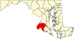
This is a locator map showing Charles County in Maryland. For more information, see Commons:United States county locator maps.
Autor:
- real name: Artur Jan Fijałkowski
- pl.wiki: WarX
- commons: WarX
- mail: [1]
- jabber: WarX@jabber.org
- irc: [2]
- software: own perl scripts
Piramida wieku dla hrabstwa Charles w stanie Maryland w USA na podstawie spisu ludności z 2000 roku
The official flag of Charles County, Maryland, designed in 1976 by Ruby Dyson and Mary Keech Edelen. More information regarding the flag can be found here.
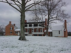
Thomas Stone's Home, Haberdeventure


