Hrabstwo Cherokee (Georgia)
| hrabstwo | |
 Droga do Jeziora Arrowhead. | |
| Państwo | |
|---|---|
| Stan | |
| Siedziba | |
| Kod statystyczny | |
| Powierzchnia | 1124 km² |
| Populacja (2020) • liczba ludności |
|
| • gęstość | 245 os./km² |
| Strefa czasowa | |
Położenie na mapie Georgia | |
| 34°14′24″N 84°28′12″W/34,240000 -84,470000 | |
| Strona internetowa | |
| Portal | |
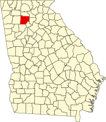
Hrabstwo Cherokee – hrabstwo położone w USA w stanie Georgia z siedzibą w mieście Canton. Założone w 1831 roku. Największe miasto w hrabstwie to Woodstock. Należy do obszaru metropolitalnego Atlanty.
Sąsiednie hrabstwa
- Hrabstwo Pickens (północ)
- Hrabstwo Dawson (północny wschód)
- Hrabstwo Forsyth (wschód)
- Hrabstwo Fulton (południowy wschód)
- Hrabstwo Cobb (południe)
- Hrabstwo Bartow (zachód)
- Hrabstwo Gordon (północny zachód)
Miasta
- Ball Ground
- Canton
- Holly Springs
- Mountain Park
- Nelson
- Waleska
- Woodstock
Demografia
Według spisu w 2020 roku liczy 266,6 tys. mieszkańców, co oznacza wzrost o 24,4% od poprzedniego spisu z roku 2010[2]. Według danych z 2020 roku, 85,1% populacji stanowili biali (78,2% nie licząc Latynosów), następnie 7,0% to byli czarnoskórzy lub Afroamerykanie, 3,8% było rasy mieszanej, 1,9% Azjaci, 0,3% to rdzenna ludność Ameryki i 0,09% pochodziło z wysp Pacyfiku. Latynosi stanowili 10,7% populacji[3].
Do największych grup należały osoby pochodzenia angielskiego (13,3%), irlandzkiego (11,9%), niemieckiego (11,7%), „amerykańskiego” (8,9%), afroamerykańskiego, meksykańskiego (4,9%), włoskiego (4,6%), szkockiego lub szkocko–irlandzkiego (4,6%) i francuskiego (3,5%)[3].
Wysoki odsetek osób pochodzenia polskiego mają miasta: Ball Ground (4,4%) i Woodstock (3,6%)[4].
Religia
W 2010 roku trzy największe denominacje w hrabstwie, to: Południowa Konwencja Baptystów (44,9 tys. członków), Zjednoczony Kościół Metodystyczny (14,9 tys.) i Kościół katolicki (9,6 tys.). Lokalne bezdenominacyjne zbory ewangelikalne zrzeszały 7,9 tys. członków w 20 zborach. Ponadto co najmniej 1 tys. członków mieli także: zielonoświątkowcy, inni metodyści, campbellici, mormoni, inni baptyści i liberalni luteranie[5].
Polityka
Hrabstwo Cherokee jest najludniejszym hrabstwem w Georgii i w obszarze metropolitalnym Atlanty, które ma większość republikańską. W wyborach prezydenckich w 2020 roku, 68,7% wyborców oddało głos na Donalda Trumpa i 29,5% na Joe Bidena[6][7].
Drogi główne
 Autostrada międzystanowa nr 75
 Interstate 575
 State Route 5
 State Route 5 Business
 State Route 5 Connector
 State Route 20
 State Route 92
 State Route 108
 State Route 140
 State Route 369
 State Route 372
Zobacz też
Przypisy
- ↑ County FIPS Code Listing for the State of GEORGIA (ang.). [dostęp 2012-11-16].
- ↑ U.S. Census Bureau QuickFacts: Cherokee County, Georgia, www.census.gov [dostęp 2022-07-30] (ang.).
- ↑ a b 2020: ACS 5-Year Estimates Data Profiles (DP05/DP02), data.census.gov [dostęp 2022-07-30].
- ↑ 2020: ACS 5-Year Estimates Data Profiles, data.census.gov [dostęp 2022-08-26].
- ↑ Cherokee County (Georgia) - Religious Traditions, 2010, www.thearda.com [dostęp 2022-07-30].
- ↑ Cherokee County, GA Political Map – Democrat & Republican Areas in Cherokee County | BestNeighborhood.org, bestneighborhood.org [dostęp 2022-07-30].
- ↑ Georgia presidential election results 2020: Live results and polls, www.nbcnews.com [dostęp 2022-07-30].
Media użyte na tej stronie
The flag of Navassa Island is simply the United States flag. It does not have a "local" flag or "unofficial" flag; it is an uninhabited island. The version with a profile view was based on Flags of the World and as a fictional design has no status warranting a place on any Wiki. It was made up by a random person with no connection to the island, it has never flown on the island, and it has never received any sort of recognition or validation by any authority. The person quoted on that page has no authority to bestow a flag, "unofficial" or otherwise, on the island.
This is a locator map showing Cherokee County in Georgia. For more information, see Commons:United States county locator maps.
Georgia state route marker. Signs use FHWA type D or type C font.
Georgia state route marker. Signs use FHWA type D or type C font.
Georgia state route marker. Signs use FHWA type D or type C font.
Georgia state route marker. Signs use FHWA type D or type C font.
Georgia state route marker. Signs use FHWA type D or type C font.
Georgia state route marker. Signs use FHWA type D or type C font.
Autor:
- real name: Artur Jan Fijałkowski
- pl.wiki: WarX
- commons: WarX
- mail: [1]
- jabber: WarX@jabber.org
- irc: [2]
- software: own perl scripts
Piramida wieku dla hrabstwa Cherokee w stanie Georgia w USA na podstawie spisu ludności z 2000 roku
Autor: Thomson200, Licencja: CC0
Orange United Methodist Church
Georgia state route marker. Signs use FHWA type D or type C font.
Georgia state route marker. Signs use FHWA type D or type C font.
Autor: Thomson200, Licencja: CC0
Lost Town Trail (road to Lake Arrowhead) during the January 2016 blizzard
600 mm by 600 mm (24 in by 24 in) Interstate shield, made to the specifications of the 2004 edition of Standard Highway Signs (sign M1-1). Uses the Roadgeek 2005 fonts. (United States law does not permit the copyrighting of typeface designs, and the fonts are meant to be copies of a U.S. Government-produced work anyway.) Colors are from [1] (Pantone Red 187 and Blue 294), converted to RGB by [2]. The outside border has a width of 1 (1 mm) and a color of black so it shows up; in reality, signs have no outside border.
Georgia state route marker. Signs use FHWA type D or type C font.


