Hrabstwo Collin
| hrabstwo | |||||
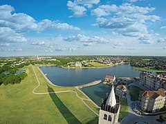
 Miasto McKinney z lotu ptaka | |||||
| |||||
| Państwo | |||||
|---|---|---|---|---|---|
| Stan | |||||
| Siedziba | McKinney | ||||
| Data powstania | 1846[1] | ||||
| Powierzchnia | 2 294 km² | ||||
| Populacja (2020) • liczba ludności | 1 064 465 | ||||
| • gęstość | 488 os./km² | ||||
| Strefa czasowa | UTC-6:00 UTC-5:00 | ||||
Położenie na mapie Teksas | |||||
| 33°10′48″N 96°34′48″W/33,180000 -96,580000 | |||||
| Strona internetowa | |||||
| Portal | |||||
Hrabstwo Collin – hrabstwo położone w Stanach Zjednoczonych w północno-wschodniej części stanu Teksas[2]. Hrabstwo utworzono w 1846 roku z terytorium nienależącym wówczas do żadnego hrabstwa, jednak jeszcze przez osiem lat podlegało przemianom a ostateczny kształt uzyskało w 1854 r[1]. Największym miastem hrabstwa jest Plano (ponad jedna czwarta mieszkańców hrabstwa[3]), jednak siedzibą władz hrabstwa jest miasto McKinney. Hrabstwo Collin jest północną i północno–wschodnią częścią obszaru metropolitarnego Dallas–Fort Worth.
Nazwa hrabstwa pochodzi od nazwiska Collina Mckinneya, mierniczego, polityka, sygnatariusza teksańskiej Deklaracji Niepodległości[4][2].
Na terenie hrabstwa znajduje się duży zbiornik retencyjny Lavon Lake zbudowany na odnodze rzeki Trinity River[5][2].
Sąsiednie hrabstwa
- Hrabstwo Grayson (północ)
- Hrabstwo Fannin (północny wschód)
- Hrabstwo Hunt (wschód)
- Hrabstwo Rockwall (południowy wschód)
- Hrabstwo Dallas (południe)
- Hrabstwo Denton (zachód)
Miasta
Demografia
W latach 2010–2020 populacja hrabstwa wzrosła o 36,1% przekraczając 1 milion mieszkańców i tym samym jest szóstym najbardziej zaludnionym hrabstwem Teksasu. W 2020 roku 69,3% ludności stanowią biali (55,1% nie licząc Latynosów), 16,3% miało pochodzenie azjatyckie, 15,5% to Latynosi, 10,9% to czarni lub Afroamerykanie, 2,8% było rasy mieszanej i 0,7% to rdzenna ludność Ameryki[3].
Główne drogi
Przez teren hrabstwa przebiegają dwie drogi krajowe oraz kilka stanowych (w tym kilka płatnych):
 U.S. Highway 75
 U.S. Highway 380
 Droga stanowa nr 5
 Droga stanowa nr 78
 Droga stanowa nr 289
Przypisy
- ↑ a b Texas: Individual County Chronologies (ang.). [dostęp 2018-01-30]. [zarchiwizowane z tego adresu (2015-05-13)].
- ↑ a b c David Minor: Collin County (ang.). Handbook of Texas Online, Texas State Historical Association. [dostęp 2018-01-31].
- ↑ a b U.S. Census Bureau QuickFacts: Plano city, Texas; Collin County, Texas; Texas, www.census.gov [dostęp 2022-02-04] (ang.).
- ↑ Lois Garver: Mckinney, Collin (ang.). Handbook of Texas Online, Texas State Historical Association. [dostęp 2018-01-31].
- ↑ Lavon Lake (ang.). Fort Worth District, Water Management Information. [dostęp 2018-01-31].
Media użyte na tej stronie
The flag of Navassa Island is simply the United States flag. It does not have a "local" flag or "unofficial" flag; it is an uninhabited island. The version with a profile view was based on Flags of the World and as a fictional design has no status warranting a place on any Wiki. It was made up by a random person with no connection to the island, it has never flown on the island, and it has never received any sort of recognition or validation by any authority. The person quoted on that page has no authority to bestow a flag, "unofficial" or otherwise, on the island.
750 mm × 600 mm (30 in × 24 in) U.S. Highway shield, made to the specifications of the 2004 edition of Standard Highway Signs. (Note that there is a missing "J" label on the left side of the diagram.) Uses the Roadgeek 2005 fonts. (United States law does not permit the copyrighting of typeface designs, and the fonts are meant to be copies of a U.S. Government-produced work anyway.)
This is a locator map showing Collin County in Texas. For more information, see Commons:United States county locator maps.
Seal of Collin County, Texas
Flag of Collin County, Texas
600 mm × 600 mm (24 in × 24 in) U.S. Highway shield, made to the specifications of the 2004 edition of Standard Highway Signs. (Note that there is a missing "J" label on the left side of the diagram.) Uses the Roadgeek 2005 fonts. (United States law does not permit the copyrighting of typeface designs, and the fonts are meant to be copies of a U.S. Government-produced work anyway.)
Autor:
- real name: Artur Jan Fijałkowski
- pl.wiki: WarX
- commons: WarX
- mail: [1]
- jabber: WarX@jabber.org
- irc: [2]
- software: own perl scripts
Piramida wieku dla hrabstwa Collin w stanie Teksas w USA na podstawie spisu ludności z 2000 roku
Autor: Mistermckinney, Licencja: CC BY-SA 4.0
Aerial photograph of Adriatica Village in McKinney, Texas


