Hrabstwo Erie (Ohio)
| hrabstwo | |||
 | |||
| |||
| Państwo | |||
|---|---|---|---|
| Stan | |||
| Siedziba | |||
| Kod statystyczny | FIPS 6-4: 39043 | ||
| Powierzchnia | 1 621,72 km²[1] | ||
| Populacja (2010) • liczba ludności |
| ||
| • gęstość | 116,76 os./km² | ||
| Strefa czasowa | UTC-5/-4 | ||
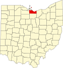
Położenie na mapie Ohio | |||
| 41°24′03,75″N 82°37′45,25″W/41,401042 -82,629236 | |||
| Portal | |||
Hrabstwo Erie (ang. Erie County) – hrabstwo w stanie Ohio w Stanach Zjednoczonych. Obszar całkowity hrabstwa obejmuje powierzchnię 626,15 mil2 (1 621,72 km2). Według danych z 2010 r. hrabstwo miało 77 079 mieszkańców[2]. Hrabstwo powstało 16 marca 1838 roku, a jego nazwa pochodzi od indiańskiego plemienia Erierów, którzy zamieszkiwali tereny wzdłuż Wielkich Jezior.
Sąsiednie hrabstwa
- Hrabstwo Lorain (wschód)
- Hrabstwo Huron (południe)
- Hrabstwo Sandusky (zachód)
- Hrabstwo Ottawa (północny zachód)
Na północy hrabstwo graniczy na Jeziorze Erie z kanadyjskimi hrabstwami Essex, Chatham-Kent oraz Ontario.
Miasta
CDP
- Beulah Beach
- Crystal Rock
- Mitiwanga
- Whites Landing
Wioski
- Bay View
- Berlin Heights
- Castalia
- Kelleys Island
- Milan
Linki zewnętrzne
- American FactFinder (ang.). [dostęp 2012-03-25]. [zarchiwizowane z tego adresu (2019-05-21)].
Przypisy
- ↑ Census 2000 U.S. Gazetteer Files: Counties (ang.). [dostęp 2012-05-11].
- ↑ QuickFacts from the US Census Bureau (ang.). [dostęp 2012-05-21].
Media użyte na tej stronie
The flag of Navassa Island is simply the United States flag. It does not have a "local" flag or "unofficial" flag; it is an uninhabited island. The version with a profile view was based on Flags of the World and as a fictional design has no status warranting a place on any Wiki. It was made up by a random person with no connection to the island, it has never flown on the island, and it has never received any sort of recognition or validation by any authority. The person quoted on that page has no authority to bestow a flag, "unofficial" or otherwise, on the island.
Autor: Rona Proudfoot, Licencja: CC BY-SA 2.0
The Boy with the Boot statue was given to the city of Sandusky by Voltaire Scott. It was displayed in Scott's Park at the foot of Wayne Street, beginning in 1895. After Scott's death, the statue was stored in the city greenhouse. In the 1930's, it was placed in a fountain in front of the courthouse in Washington Park. There are several similar statues in the United States and abroad.
The Boy with the Boot serves as the unofficial mascot of the city of Sandusky. After several acts of vandalism in the 1990's, a second statue was cast in bronze. The original zinc statue stands in the lobby of the City Hall building, while the bronze Boy with the Boot remains in Washington Park year round.
<a href="http://www.ci.sandusky.oh.us/horticulture/Washingtonpark.htm">Washington Park Web site</a>
<a href="http://www.roadsideamerica.com/set/boot.html">Other "boys with boots" around the country</a>Locator map of Erie County — along Lake Erie in northern Ohio.
- Credits
- David Benbennick made this map. For more information, see Commons:United States county locator maps.
Seal of Erie County, Ohio


