Hrabstwo Esmeralda
| hrabstwo | |
 | |
| Państwo | |
|---|---|
| Stan | |
| Siedziba | |
| Kod statystyczny | FIPS 6-4: 32009 |
| Powierzchnia | 9295 km² |
| Populacja (2006) • liczba ludności |
|
| • gęstość | 1 os./km² |
Położenie na mapie Nevada | |
| Portal | |
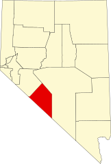
Hrabstwo Esmeralda – hrabstwo w południowo-zachodniej części stanu Nevada. Gęstość zaludnienia wynosi ok. 0,1 osoby na km². Stolicą jest Goldfield.
Historia
Esmeralda jest jednym z dziewięciu pierwotnych hrabstw Terytorium Nevady utworzonych w 1861. Jego nazwa znaczy po hiszpańsku szmaragd. Nadał ją jeden z pierwszych górników w tych okolicach J. M. Corey, prawdopodobnie na cześć cygańskiej tancerki z książki Victora Hugo Katedra Marii Panny w Paryżu. Stolicą została początkowo osada Aurora. W 1883 władze przeniosły się do Hawthorne. W 1907 ostatecznie przeniesione zostały do Goldfield.
Podstawą gospodarki na początku XX wieku była eksploatacja złota. Zasoby większości kopalni zostały wyczerpane w latach 1910-1919. Od tego czasu hrabstwo podupadło gospodarczo, a wraz z kryzysem zmniejszyła się jego ludność.
Geografia
Całkowita powierzchnia wynosi 9295 km² z czego tylko 1 km² (0,01%) stanowi woda.
Nad hrabstwem dominuje łańcuch górski Monte Cristo i góra Silver Peak.
W hrabstwie leży miasto-widmo: Gold Point.
CDP
- Dyer
- Goldfield
- Silver Peak
Populacja wybranych miejscowości
- Coaldale (w 2000 r. – 20 osób; sześć lat później – zero)
- Dyer (w 2000 r. – 110 osób; w 2006 r.- 400)
- Goldfield (w 2000 r. – 500)
- Gold Point (w 2000 r. – 20; w 2006 r.- 8)
- Lida (0 osób)
- Silver Peak (w 2000 r. – 200)
- Boundary Peak (4007 m), najwyższy szczyt w Nevadzie.
- Piper Peak, (2880 m)
- Magruder Mountain (2756 m)
- Montezuma Peak (2552 m)
- Emigrant Peak, (2069 m)
Sąsiednie hrabstwa
- Mineral – północny zachód
- Nye – wschód
- Inyo w Kalifornii – południe
- Mono w Kalifornii – zachód
Edukacja
W całym hrabstwie znajdują się tylko trzy szkoły, do których uczęszcza się ok. 90 uczniów:
- Dyer Elementary School
- Goldfeild Elementary
- Silver Peak Elementary
Media użyte na tej stronie
The flag of Navassa Island is simply the United States flag. It does not have a "local" flag or "unofficial" flag; it is an uninhabited island. The version with a profile view was based on Flags of the World and as a fictional design has no status warranting a place on any Wiki. It was made up by a random person with no connection to the island, it has never flown on the island, and it has never received any sort of recognition or validation by any authority. The person quoted on that page has no authority to bestow a flag, "unofficial" or otherwise, on the island.
Flag of the State of Nevada. The flag is described in Nevada Revised Statutes Chapter 235, Sec. 20 as follows: The body of the flag must be of solid cobalt blue. On the field in the upper left quarter thereof must be two sprays of Sagebrush with the stems crossed at the bottom to form a half wreath. Within the sprays must be a five-pointed silver star with one point up. The word “Nevada” must also be inscribed below the star and above the sprays, in a semicircular pattern with the letters spaced apart in equal increments, in the same style of letters as the words “Battle Born.” Above the wreath, and touching the tips thereof, must be a scroll bearing the words “Battle Born.” The scroll and the word “Nevada” must be golden-yellow. The lettering on the scroll must be black-colored sans serif gothic capital letters.
Autor: FloNight (Sydney Poore) and Russell Poore, Licencja: CC BY-SA 3.0
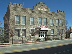
Esmeralda County, Nevada courthouse, located on Crook Avenue (U.S. Route 95) in Goldfield, Nevada
Autor:
- real name: Artur Jan Fijałkowski
- pl.wiki: WarX
- commons: WarX
- mail: [1]
- jabber: WarX@jabber.org
- irc: [2]
- software: own perl scripts
Piramida wieku dla hrabstwa Esmeralda w stanie Nevada w USA na podstawie spisu ludności z 2000 roku
This is a locator map showing Esmeralda County in Nevada. For more information, see Commons:United States county locator maps.


