Hrabstwo Harford
| hrabstwo | |||||
 | |||||
| Państwo | |||||
|---|---|---|---|---|---|
| Stan | |||||
| Siedziba | |||||
| Kod statystyczny | FIPS 6-4: 24025 | ||||
| Powierzchnia | 1 364,20 km² | ||||
| Populacja (2000) • liczba ludności |
| ||||
| • gęstość | 191,7 os./km² | ||||
| Strefa czasowa | UTC -5:00/-4:00 | ||||
Położenie na mapie Maryland | |||||
| Portal | |||||
Hrabstwo Harford (ang.: Harford County) – hrabstwo w amerykańskim stanie Maryland. Hrabstwo zajmuje powierzchnię całkowitą 1 364,20 km² i według szacunków US Census Bureau w roku 2006 liczyło 241 402 mieszkańców. Siedzibą hrabstwa jest miejscowość Bel Air.
Historia
Hrabstwo Harford powstało w 1773 roku z części hrabstwa Baltimore. Nazwa hrabstwa pochodzi od Henry'ego Harforda, ostatniego właściciela kolonii Maryland, który jako nieślubne dziecko Fredericka Calverta, szóstego lorda Baltimore, nie odziedziczył po ojcu tytułu lordowskiego.
Geografia
Hrabstwo Harford zajmuje powierzchnię całkowitą 1 364,20 km², z czego 1 140,50 km² stanowi powierzchnia lądowa a 223,70 km² (16,4%) powierzchnia wodna. Najwyższy punkt w hrabstwie ma wysokość 245 m n.p.m., zaś najniższy punkt położony jest na poziomie morza w zatoce Chesapeake.
Na terenie hrabstwa Harford znajdują się trzy parki stanowe: park stanowy Palmer, park stanowy Rocks oraz park stanowy Susquehanna.
Miasta
CDP
- Bel Air North
- Bel Air South
- Darlington
- Edgewood
- Fallston
- Jarrettsville
- Joppatowne
- Perryman
- Pleasant Hills
- Pylesville
- Riverside
Demografia
Według szacunków US Census Bureau w roku 2006 hrabstwo Harford liczyło 241 402 mieszkańców.
Bibliografia
- Podstawowe dane statystyczne o hrabstwie Harford US Census Bureau (en)
- Podstawowe dane statystyczne dotyczące hrabstw w stanie Maryland US Census Bureau (en)
- Najniżej i najwyżej położone punkty w hrabstwach w Maryland. mgs.md.gov. [zarchiwizowane z tego adresu (2014-01-03)]. Maryland Geological Survey (en)
- Profil hrabstwa Harford Maryland State Archives (en)
Media użyte na tej stronie
The flag of Navassa Island is simply the United States flag. It does not have a "local" flag or "unofficial" flag; it is an uninhabited island. The version with a profile view was based on Flags of the World and as a fictional design has no status warranting a place on any Wiki. It was made up by a random person with no connection to the island, it has never flown on the island, and it has never received any sort of recognition or validation by any authority. The person quoted on that page has no authority to bestow a flag, "unofficial" or otherwise, on the island.
This is a locator map showing Harford County in Maryland. For more information, see Commons:United States county locator maps.
The official seal of Harford County, Maryland, designed by George Van Bibber in September 1964. Additional information about the seal itself can be found here.
Flag of Harford County, Maryland
Autor:
- real name: Artur Jan Fijałkowski
- pl.wiki: WarX
- commons: WarX
- mail: [1]
- jabber: WarX@jabber.org
- irc: [2]
- software: own perl scripts
Piramida wieku dla hrabstwa Harford w stanie Maryland w USA na podstawie spisu ludności z 2000 roku
Autor: Jerrye & Roy Klotz, MD, Licencja: CC BY-SA 3.0
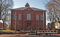
THIS BUILDING IN BRICK ITALIANATE STYLE WAS BUILT IN 1858 TO REPLACE THE ORIGINAL 1791 COURTHOUSE WHICH BURNT DOWN.


