Hrabstwo Jasper (Missisipi)
| hrabstwo | |
 | |
| Państwo | |
|---|---|
| Stan | |
| Siedziba | Bay Springs |
| Kod statystyczny | FIPS 6-4: 28061 |
| Powierzchnia | 1754,56 km²[1] |
| Populacja (2009) • liczba ludności |
|
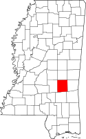
Położenie na mapie Missisipi | |
| 32°01′12″N 89°07′12″W/32,020000 -89,120000 | |
| Strona internetowa | |
| Portal | |
Hrabstwo Jasper (ang. Jasper County) – hrabstwo w stanie Missisipi w Stanach Zjednoczonych. Obszar całkowity hrabstwa obejmuje powierzchnię 677,44 mil² (1754,56 km²). Według szacunków United States Census Bureau w roku 2009 miało 17 940 mieszkańców[2].
Hrabstwo powstało w 1833 roku[3].
Miejscowości
- Bay Springs
- Heidelberg
- Louin
- Montrose[4]
| Populacja hrabstwa w poprzednich latach[3] | |
|---|---|
| Rok | Liczba ludności |
| 1980 | 17 430 |
| 1990 | 17 114 |
| 2000 | 18 149 |
| 2005 | 18 162 |
Przypisy
- ↑ US Census Bureau: Population, Housing Units, Area, and Density: 2000. [dostęp 2012-05-18]. [zarchiwizowane z tego adresu (2016-03-09)]. (ang.).
- ↑ a b US Census Bureau: Jasper County. Quickfacts. [dostęp 2011-04-16]. (ang.).
- ↑ a b National Association of Counties: Jasper County, MS. [dostęp 2011-04-16]. (ang.).
- ↑ National Association of Counties: Places in Jasper County, MS. [dostęp 2011-04-16]. (ang.).
Media użyte na tej stronie
The flag of Navassa Island is simply the United States flag. It does not have a "local" flag or "unofficial" flag; it is an uninhabited island. The version with a profile view was based on Flags of the World and as a fictional design has no status warranting a place on any Wiki. It was made up by a random person with no connection to the island, it has never flown on the island, and it has never received any sort of recognition or validation by any authority. The person quoted on that page has no authority to bestow a flag, "unofficial" or otherwise, on the island.
This is a locator map showing Jasper County in Mississippi. For more information, see Commons:United States county locator maps.
Autor: Rocky Vaughn, Sue Anna Joe, Dominique Pugh, Clay Moss, Kara Giles, and the Mississippi Department of Archives and History, Licencja: Copyrighted free use
The state flag of Mississippi, created in 2020 and adopted in 2021. Known as the "New Magnolia", it was the final design selected by the Commission to Redesign the Mississippi State Flag in 2020.
Autor: NatalieMaynor, Licencja: CC BY 2.0
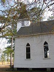
I took this picture a few days ago as a cemetery-separator -- to show where on the camera card a new cemetery began. But in looking at it now, I kind of like it as a picture in its own right. Montrose Presbyterian Church, Jasper County, Mississippi.


